Wednesday, April 26, 2006
(April 7 2006 continued....)Since the Southend cone came from a small tree with 90 mm long needles in pairs within each cluster on a twig it was relatively easy to identify the cone as the Maritime Pine Pinus pinaster Aiton. The Chalkwell cone resembled the scales of the Stone Pine Pinus pinea L. but in stranded material from the Netherlands side of the North Sea the cone length varied from 80 to 150 mm at a much greater diameter of 100 mm (C.J.E. Brochard, G.C. Cadée 2005, Tropische drijfzaden van de Nederlandse kust, in Tabellensie Strandwerkgemeenschap no. 30). The Kriobcone Pine Pinus attenuata Lemmon with a length of 140 mm at Texel and 130 mm at Schiermonnikoog is a better match in general shape except for the Kriobs which could perhaps have become worn or lost at Chalkwell. It would be instructive to see which species were being sold in England and Canada as ornaments last Christmas and how long these two cones will float.
Tuesday, April 25, 2006
April 7 2006. The tidal cycle of 14 days first described by a stranding of cuttlebones low on the Southend-on-Sea beaches on March 24 is now repeated by the morning predicted tide at 1.6 m above mean sea-level (O.D) surveyed as a largely algal strandline for 1.8 km east of Chalkwell Station, 0.8 km at Shoebury East Beach and 4.2 km from South Shoebury to Southend Pier. The only new find of a cuttlebone was on the old highest strandline at the East Beach, measured as actually only 1.5 m above the latest strandline using the top of the anti-E-Boat Boom as a horizontal datum. This cuttlebone with an intact width of 35 mm and broken at both ends was probably stranded 14 days before and moved to the higher point on the same or an adjacent beach over the next seven days. After that it was presumably hidden from my surveys by algae since decayed and dry enough to be winnowed by the generally westerly winds there. The new strandline is one of four to eight seen on various parts of the beaches and like them is largely composed of brown algae, a few reeds, whelk egg cases and an offshore ridge of flint gravel or bivalve shells. Abundant reeds are largely concentrated in the two highest strandlines and one in the middle, and confined to the south-facing coast.
Two new finds made today were a spiny spider crab (Maja squinado) with intact legs joined to an entirely predated dorsal carapace and body (eastern Southend) and a pine cone on the same lowest strandline at Chalkwell Shelter with the axis parallel to the shore. It was larger than the usual pinecones seen growing locally, except for one near Southend Pier. Having obtained a cone from there and let it contract in width from 80 to 51 mm in sea-water, it became clear that it was not the source.
Two new finds made today were a spiny spider crab (Maja squinado) with intact legs joined to an entirely predated dorsal carapace and body (eastern Southend) and a pine cone on the same lowest strandline at Chalkwell Shelter with the axis parallel to the shore. It was larger than the usual pinecones seen growing locally, except for one near Southend Pier. Having obtained a cone from there and let it contract in width from 80 to 51 mm in sea-water, it became clear that it was not the source.
Characteristics                   Chalkwell         Southend
Length                            130 mm            105 mm
Diameter (from circumference)      59 mm             51 mm
Dia. of attachment stalk           12 mm              8 mm
Cone axis to stalk axis             0 mm             10 mm
Largest width of scales            21 mm             16 mm
Axial scale dimension         less than 11      less than 11
scale number of sides               4                 6
central umbo                      flat             spine
colour                           dark           pale brown
features                axial split scales   scales intact
Monday, April 24, 2006
April 3 2006. The beach walk was repeated during and after the quarter to five pm (British summer Time) tide of 2.5 m O.D. predicted altitude. At Shoebury East Beach, as elsewhere, the tides over the weekend had added another gravel ridge capped by a reed-dominated strandline, below the previously examined one with cuttlebones (three more being found there, but not elsewhere where the reeds still resemble piles of hay in most places). The new and relatively sparse strandline was formed by waves breaking during a gentle, warm, dry westerly breeze, producing a large human population by sunset and stranding partly eaten apples and cucumbers slices. More generally there were reeds which had been out of the marsh for some days; being smaller and bound together by more common brown algae like those ’floral tributes’ seen by the roadside after accidents. Driftwood and leaves were more common, or at least more conspicuous, than before. Probably the leaves were washed into the sea the day before when the westerly rain squalls had roughly coincided with the relatively low predicted tide around 4 p.m. That rain may have also helped to cut the two reed bands into a vertical sand cliff near Lynton Road in Thorpe Bay. The base of it was far above the level of the new strandline there. The only place where fresh, unbound and larger reed debris were present in this new lower strandline was about 1.0 km east of Chalkwell Station (near the Westcliff Toilets). To the west of that spot the new strandline was hardly visible at all. In the east, half a coconut was stranded like a boat in Thorpe Bay (below Tyrone Road) and spinose Echinocardium were seen again in South Shoebury.
An interesting find was of a sliced but otherwise intact coconut stranded concave-up like a boat on the sand of the new strandline in Thorpe Bay below Tyrone road. It could not have been broken on the seawall there, as even the two old hayfield strandlines did not reach it. It also could not have come far before enough water would have entered the concavity of the white and locally bird-pecked endosperm flesh to sink it. In a static subsequent test it sank within four hours by water leaking around the edge of the fractured nut wall and straight away in the concave down orientation likely to be soon produced by waves today. I have seen coconuts floating like boats before at Southend and imagine that they sink on to the mudflats soon after being split on impact with the sea wall pier, or breakwaters. Then having been pecked at for one tidal cycle they can come back in as hemispherical boats to strand.
I use to think that local humans put them into the sea at Southend during picnics, but this is unlikely since they would presumably then eat at least part of the endosperm flesh having gone to the trouble of breaking the top off (which is not easy unless you go to the seaside with a machete and so run the risk of arrest on the train’s new detectors for weapons etc.). It is true that both half-eaten apples and slice cucumber were on the new strandline, but that is more easily understood as overfeeding in lunch boxes. Probably the coconuts are put into the sea as part of Hindu rituals, perhaps in London canals far away? It would be interesting to relate their dispersal to particular dates and modes of preservation when they start their journey .


Sunday, April 23, 2006
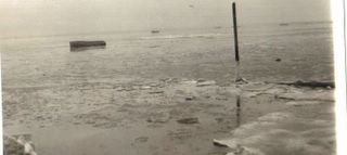
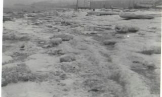
April 2 2006. On going to Chalkwell Beach this morning at low tide the water in the paddling pool was warm and proved to be 50°F (10°C) to disprove my earlier remarks about not bathing there. This winter the snow has melted above the water level there. The sampled water was not below 37°F (2°C), but ice has build up at that spot in colder years in a similar way to the reeds now shifted up the beach by several high tides since my last observation of it spread on the now clean lower sands. Quite recently (?Jan 1991), I noticed a Canadian-style ice-float above the tide mark cementing the sands there. A set of photographs taken west looking towards Chalkwell station, out towards ice rafts coming from Canvey Island, the Crowstone to the east and of boats at Old Leigh, show the sea nicely frozen on the morning of 26 January 1963. My father took them on a morning described as a thaw in my diary, when the tide due about 13:10 hours G.M.T. had not been so high for 14 days. One can see the height at the time the photographs were taken from the ice flows around the inscription plate on the Crowstone, to be lower than at that high tide.
Today the most interesting find was a intact, buoyant coconut with one 'eye' missing to expose a hole through the underlying endosperm produced either by decay in the sea, or during the Hindu ritual? It was below the strandline at the usual spot for stranded birds at the station, perhaps because it had rolled back with the tide or been kicked there. A husk of coir, almost certainly of the same coconut was in the latest strandline of reeds about 100 m to the east (beyond one breakwater). A Breast Cancer Charity walk to the Halfway House and back (from Leigh Station) was going on. It was hopefully over before heavy rain arrived in the west wind at 3 p.m.
Today the most interesting find was a intact, buoyant coconut with one 'eye' missing to expose a hole through the underlying endosperm produced either by decay in the sea, or during the Hindu ritual? It was below the strandline at the usual spot for stranded birds at the station, perhaps because it had rolled back with the tide or been kicked there. A husk of coir, almost certainly of the same coconut was in the latest strandline of reeds about 100 m to the east (beyond one breakwater). A Breast Cancer Charity walk to the Halfway House and back (from Leigh Station) was going on. It was hopefully over before heavy rain arrived in the west wind at 3 p.m.
Friday, April 21, 2006
(March 29, 2006 continued...) This extended to Leigh at around 1.5 m O.D., where the main evidence of the actual strandline was an older pile of reeds nearly at the road level in the protected gulley on the east side of Bell Wharf. These older reeds were virtually absent from the high beach gravels between Lynton Road and Southend Pier and concentrated on the west side of the Casino and various breakwaters at South Shoebury. It would seem likely that the reeds come from the northern marshland around Canvey Island when the tide is high enough and that they cannot reach even the adjacent Leigh to Chalkwell station beach before the tide has ebbed for several hours. Presumably during the next tide, of any level, they will shift eastwards to Shoebury, particularly if the wind was from the south and west as it was on March 29 and the day before. Reeds float well but the bitten cuttlebones refloated in seawater on March 24 had sunk by 22:00 hrs GMT on March 30.
There were only two finds of new cuttlebones on the March 29 strandline-one on Shoebury East Beach where the wind was blowing parallel to the beach and one just east of Warwick Road, about 250 m west of the previous Lynton Road find in Thorpe Bay. This was roughly where the reeds start to thin out westwards on March 29 and eastwards on March 24. Using a compass, which I had taken this time since I expected that cuttlebones might be seen, one could determine that the narrower (posterior) end of the dorsal-up shell was pointing 155° east of magnetic north (S.S.E.) where the reeds and brown algae defined a strandline trending 110° east of magnetic north (true north is about 2 degrees east of magnetic north locally at present). The shell had a width of 29 mm and a preserved length of 55 mm and the one from Shoebury 42 mm and 82 mm.
There were only two finds of new cuttlebones on the March 29 strandline-one on Shoebury East Beach where the wind was blowing parallel to the beach and one just east of Warwick Road, about 250 m west of the previous Lynton Road find in Thorpe Bay. This was roughly where the reeds start to thin out westwards on March 29 and eastwards on March 24. Using a compass, which I had taken this time since I expected that cuttlebones might be seen, one could determine that the narrower (posterior) end of the dorsal-up shell was pointing 155° east of magnetic north (S.S.E.) where the reeds and brown algae defined a strandline trending 110° east of magnetic north (true north is about 2 degrees east of magnetic north locally at present). The shell had a width of 29 mm and a preserved length of 55 mm and the one from Shoebury 42 mm and 82 mm.
Thursday, April 20, 2006
(March 29, 2006 continued….) In summer it is more difficult to trace a strandline since there is a tendency for people to sit on it during dry weather when such surveys are easier to do. I did the whole route on June 21 2002 when a national sporting contest cleared the more crowded areas of the beach around Southend. In that case the predicted tidal level was 2.4 m O.D. and the most interesting finds were spinose sea-urchins of the genus Echinocardium and a non-spinose regular sea-urchin Psammechinus miliaris (latter stranded intact near Half Way House public house and found to float for 2.4 days when kept in seawater since it was discovered there). Echinocardium with some spines attached and so freshly stranded that they attracted the interest of flies where found today (March 29) tossed on the reeds above a gravel ridge cut by the tide along the open South Shoebury Common coastline. This also featured a cabin cruiser stranded parallel to and just below the new cliff of gravel, and a less intact smaller boat thrown with piles of the reeds under beach huts at Thorpe Bay. The reeds had evidently been transported to this area by the south and west breeze which had persisted since the last visit in which this area was devoid of reeds at all levels of the beach. Elsewhere one can imagine that the reeds had merely been reworked from the lower strandlines as the tide rose through the week, cleaning the lower sands of all their buoyant materials. However, on returning to Chalkwell Station with the tide now gone far out and the sun still not set, there was a new spread of green reeds, plastic bottles and the usual new dead bird on the lower part of the beach bordering on the mudflats.
Wednesday, April 19, 2006
(March 29, 2006 continued...) The survey of one strandline from Shoebury to Leigh done on March 24 was therefore repeated, starting at Chalkwell Station with a wild grey tide just on the ebb around 2 p.m. British Summer Time near the predicted height 3.3 m above mean sea-level (Ordnance Datum). The studied March 24 tide had a predicted altitude of 1.6 m O.D. and the next one which permitted the strandline to be studied was only predicted to reach 1.4 m O.D. Tides are highest, in terms of astronomical predictions but not weather conditions, around the Spring Equinox on March 20 and the other equinox on September 23 this year. But the highest predicted tides do not occur exactly on these dates being likely to occur one day after the full moon and one-hour after the true (not British Summer Time) midday or midnight at Southend.
Tuesday, April 18, 2006
March 29, 2006. Charles Dickens, writing in 1860 from his home at Gad’s Hill in Kent, 12 miles (21 km) south-west of Westcliff, gives a description of Cooling Churchyard and Marshes situated half way between them on a winter’s day (Great Expectation p.2):
“The dark flat wilderness beyond the churchyard, intersected with dykes and mounds and gates, with scattered cattle feeding on it, was the marshes; and the low leaden line beyond was the river; and that the distant savage lair from which the wind was rushing, was the sea.”
On can see Cooling Church from Westcliff in Southend-on-Sea, both on a nice sunny day and on that kind of windy day in which the rain showers look like black holes in the universe heading over to Kent. It is only the poor inhabitants of Kent who cannot bask in the sun on their Thames Estuary and look north. But the wind is more usually coming from Coolings in the southwest. It is not actually warm when full of rain but does at least clear away to show either the church or a romantic illusion of open sea or infinite mud flats hidden in sea fog. Today the wind is blowing from a clearly seen Cooling Church. The tide is predicted to be among the highest in the year and with little or no rain or fog about. It is a good time to repeat the walk of March 14. Just don’t go in the coldest sea-water around the U.K.
Saturday, April 15, 2006
(March 28,2006 continued....) Returning to the topic of trees in this context it is no longer possible to imagine how dark King's Hill would be before dawn and light pollution. Judging from experience elsewhere it is not particularly difficult to move over open country at night, but movement under a deciduous wood, before the leaf fall in September and without lights is another matter. One therefore wonders whether the Wednesday after St. Micheal's and all Angels Feast correlates with moonlight; but that is not the case now and how the Roman calendar worked. One can imagine people assembling the evening before the court from their wooded manors and later going through some sort of parade in a relatively open spot shortly before dawn when one can see to move about and write charcoal notes.
Friday, April 14, 2006
(March 28,2006 continued....) There is a similar local Latin text reproduced with a translation by Phillip Benton in his History of the Rochford Hundred (1867-1888). This relates to a ritual which used to take place on the sandy hill on the north side of the cutting of the AL27 road in Rayleigh, which in this earlier period would have been a good site for a King based in Prittlewell to gather defense forces from the hundred against an attack at dawn from the Welsh in London. Later on it was doubtless used to gather work force obligations for the construction of Rayleigh Park pale and other such local projects. The ritual took place on the first Wednesday, or perhaps originally Wooden's Day, after Michealsmas (perhaps once the equinox?) at dawn on this King's Hill at Rayleigh. The Latin text is:
Curia de Domino, Rege,
Dicta Sine Lege,
Tenta est ibidem,
Per ejusdem consuetudinem,
Ante ortum solis,
Luceat nisi polus
Senescallus solus
Nilscribit nisi colis
Toties volucrit
Gallus ut cantaverit
Per cujus soli sonitus (or solum sonitum)
Curia est summonita
Clamat clam pro Reye
In Curia Sine Lege
Est nisi cito venerint
Citius poenituerint
Est nisi clam accedant
Curia non attendat
Qui venerit cum lumine
Errat in regimine
Et dum sunt sine lumine
Capti sunt in crimine
Curia sine cura
Jurati de injuria.
"Apparently this says that a court of the Lord the King termed
Sine Lege, or a court of Baron, was held before dawn and that after the cocks crows the steward writes with charcoal and cries secretly for the King. The people (who presumably were asked to make obligations) at the court were instructed to arrive quickly and without lights or be held in contempt of court. One can imagine that lights on Kings Hill would be seen for miles before dawn, and then with the sunrise the King would see far into the west from there.
Thursday, April 13, 2006
(March 28, 2006 continued....) The name Camp Bling is explained by a notice posted by the protestors on an area of grass taped-off as the site of the Saxon graves excavated in the winter of 2003-4 by the British Museum. Apparently the popular press reported the small early Christian gold ornament and rather more impressive blue glass Aylesford Ware pot as the grave goods of a “king of Bling”. The existence of a coin from the Merogovians on the continent supports the dating to the time in the first half of the 7th century when the East Saxons were converted to Christianity twice, before finally being reconverted after the bad omen of the plague by Wilfred (see above). What must be the oldest recorded English conversation in London is recorded in all the history books and may now be seen to relate to the death of the first Christian king at Prittlewell and the arrival of his unbaptised and aggressive sons at St. Paul’s Cathedral within their inheritance. “Give us that white bread you gave to our father Saba”. This sounds like a more likely conversation than the one about Pope Gregory dispatching the missionaries to Kent by Rhymes in a Roman Slave Market.
Monday, April 10, 2006
March 28 2006. Visit Sutton Cemetery to check some family history dates and pass near Prittle Brook several tree houses and associated tents termed "Camp Bling" by the people who have lived there through the winter protesting against a road widening plan destructive to mature trees. Less attention has been given to the destruction of trees along both railways to Southend to prevent leaves falling on the line and causing delays to trains. One wonders whether this will work unless large tracts of the woodland outside the railway company fences are removed as well, with the now removed smaller bushes no longer trapping the more distantly blown leaves. Much will depend on the prevailing southwest wind direction during the autumn rainstorms, and the type of trees (which stagger their leaf fall until January in many oaks) and whether the track is on an embankment or not. The distance which leaves move by normal winds, normally only to the east (along many tracks) or northeast, depends on the height of the tree and is roughly ten times the height of trees, which are often 30 m high and with bases above the tracks in woodland surviving on Essex sandy hills.
Subscribe to:
Posts (Atom)