November 10 2006. The Church dedicated to St. James-the-less in the middle of the A13 road at Hadleigh was visited today for comparison of the London Clay concretion colours with the northern Essex church visited a week before. They were both largely Norman structures but at Hadleigh the stone was largely transported over the Thames from Kent in the early exciting reign of King Stephan (c.1140); probably as a secular defense measure by the church authorities. The eastern and western ends of the church were respectively repaired with the same and some new stone in 1854 (following collapse of the semicircular apse) and 1949 (following 1934-45 aerial bombing). A greater obscuration of the original fabric is due to the construction of a vestry in 1928 outside the northwest nave and a small wooden south porch in the 18th Century. There is no external tower only a wooden one on interior nave posts.
The first circuit of the exterior showed only one possible London Clay concretion in the lower two metres of all the old walls. The second more careful circuit provided a sample of colour measurements from ten stones and during a restudy of these particular stones on a third circuit this sample was reduced to 16 colours determined from four stones near the eastern ends of the nave and 8 colours determined from four less clearly London Clay concretions in the south wall of the chancel and the S.W. region of the nave beyond the porch. That corner included a probable glacial erractic of silica cemented, non-Cretaceous sandstone, with dimensions of 450 mm by 450mm that were larger than the Cretaceous sandstones and siltstones blocks obtained from Kent. There were also a few somewhat smaller slabs of ferricrete (iron oxide cemented flint gravel) in the south and west nave.
The largest stone of clearly London Clay origin had exposed dimensions of 220 mm by 180 mm shaped by splitting a concretion along prismatic calcite veins of 5 mm maximum half-thickness flanked on both sides by dark grey to moderate red, originally pyritic joint surfaces (5R 4/1-5R 4/4). The matrix of finer-grained calcite cemented clay graded from this colour, through paler browns and oranges, to a worn rather than a bored exterior weathered yellowish grey (5Y 7/2). Adding what appear to be beach-worn pebbles of the claystone matrix, the average colour of 16 studied spots is 6.56 YR 5.813/3.500 of the Munsell Co. system (i.e. roughly yellowish orange). The provinance is not the same as Broomfield Church as the veins were thicker and more pyritic but it is still unclear whether it represents division A3 of the Reculver-Herne Bay coast in Kent, or the division D/E boundary septaria which can still be found in Hadleigh Cliffs below and east of the subsequently built castle. The sea-worn appearance of some of the stones is of course opposed to that idea since Hadleigh Castle has old marshland separating it from the sea. But if the Kentish stones were landed at the more convenient port of Leigh and had their oyster-shell mortar added there i.e. even now a few whole oyster shells can be seen in the apse) then this objection is overcome. The more doubtful additional 8 colour determinations from four rather less weathered, silty-looking angular stones averaged 1.25 Y 5.750/2.875, which is roughly yellowish to olive grey. If it is reasonable to add them the general average from Hadleigh Church only shifts to 8.12 YR 5.792/3.292, which is yellowish orange. I suspect that the whole modern oyster shells used to make the mortar between the Kentish ragstone and other imported superior building stones came from London Clay shorelines on both sides of the Thames estuary. Some septaria were therefore collected with the future mortars up until the end of Church building with the reformation. It is therefore worth looking for London Clay concretions and recording their weathered colours etc in South Essex walls which are not supposed to contain them in published descriptions. Conversely when the London Clay concretions are common enough to have been noticed by visitors with more general interests, then they probably came from specific sites along the Essex or Kent coastline where they were gathered as building stones in an earlier period ending around 1200. There alternative perspective might be that a few concretions were like the Roman brick and tile fragments also seen in small numbers at Hadleigh Church and most south Essex churches, and came from the use of Saxon or Roman buildings as quarries in stone-poor Essex lands. A third idea, which I think is less likely, is that the insitu septaria seen now in fields such as those near Hadleigh Castle, were formerly gathered as additional building stones from each manor. Much will depend on how stable London Clay slopes were in ancient times when ploughing and excavation work was less easy than in modern times. However, it is relatively easy to test this local hypothesis by comparing the colours and weathered textures of church concretions with those found locally today.
Saturday, November 25, 2006
Thursday, November 16, 2006
Angel Wing’s at Broomfield
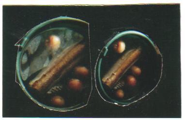
November 7 2006. During the visit to Broomfield Church in Essex last Friday, it was noticed that one cluster of London Clay concretions in the nave contained borings by the modern marine worm Poydora ciliata Johnstone not seen elsewhere at convenient elevations in the walls and associated in one 130 mm by 80 mm stone with 6 mm diameter bivalve borings and insitu shells. In eastern North America, this type of bivalve or clam are given the name Angel Wing, more by comparison with the six and elongated wing development reviewed in Isaiah 6 v.2 than more speculative Christmas card illustrations with two spread wings like a bird. The bivalves in the wall building stone had bored in when it was on the lower or middle foreshore of Essex or North Kent, with rough radial ribs extending to a diameter of 6 mm at the working face and a delicate concentric ornament of growth ridges extending towards the entrance for the shell length of at least 15 mm before the stone was collected in Roman, Saxon or earliest Norman times. A complete and fully investigated shell would probably have an additional pair of small shelly plates filling the gape between the valves at the working face, or alternatively a fused similar folded structure there. It was not clear to me which species was present as juvenile and partly hidden shells in the church. Bearing in mind the age of the wall and the lack of evidence of repairs at that spot it is unlikely that the American species Petricola pholadiformis Lamarck [False Angel Wing] needs to be carefully separated from the unrelated homeomorphic English Native species Barnea candida (L.) [White Piddock] allied to the American B. truncata say [Small Angel Wing]. Petricola was first noticed in the River Crouch Estuary of Essex in July 1890 (see N. Tebble British Bivalve Seashells (1966) p. 126). However there is also a smaller English species, which although looking wider than those in the wall are are, is known from the Kent coast and provides an alternative identification. This is Barnea parva (Pennant) [Little Piddock]. There are also larger species Pholoas dactylus L. [Common Piddock] and Zirfaea crispata (L.) which also bore into rocks in southern England but which look somewhat different to the church shells.
The host rock would once have been a large concretion embedded in the London Clay below and probably partly covered by modern mud or sand above. It was then split along natural joints and a few thin septarian calcite veins either by the sea, during collection or transport or more likely just before building of the nave. One can see that the wall consists of a regular size and shape of the stones, with similar-looking fragments of probably the same original concretion placed next to each other, and the Polydora bored surfaces concentrated at the one spot in the whole wall. Unlike many other Essex walls there are no large intact concretions, and no thick-veined or open-veined concretions present. Elsewhere in the nave and older part of the Chancel there are concretions split along sepatarian calcite veins with a half-thickness of up to 4 mm and more iron-stained prisms at the edge nearest to the calcite claystone matrix. But they are not common enough to be seen with the bored material and this suggests a source in the division B, or middle London Clay of Kent or Essex, where septarian veins are thin and sparse. However, since both veined and unveined concretions are termed septaria in archaeological accounts of Essex it is reasonable to use that name for London Clay concretions regardless of vein frequency. This stratigraphical deduction implies that the concretions were not gathered from the subsequently suitable habitat for boring bivalves in the Crouch estuary or indeed the Roach and on the Thames at Southend. These are all upper London Clay foreshore sites, termed division C to E, in which even a small sample of concretions soon shows some thicker and or more open septarian veins. At Southend one can certainly find Polydora borings but often they and other marine animal traces are so common as to make the original surface features of the concretion hard to observed. This is particularly the case with museum specimens of division B dredged-up from subtidal environments at Clacton and Whitstable in early Victorian times. In all probability this mode of collection was not known to people in Roman or Saxon times and the resulting building stones at Broomfield look as if they came from a muddy foreshore in which the sedimentation rate was fast enough to limit the growth of the oysters sometimes seen on concretions in churches.
A more direct method of working on the provenance of the bored concretions is to record the colours of the pre-collection weathering zones by direct comparison with the Geological Society of America Rock-Color chart held up in the same illumination. Holes cut in a grey cardboard (N7) are placed in front of each spot on the stones. Weathering in the wall mainly has the effect of exfoliating the outer layers and increasing the lightness value. Probably this weathering was limited by a covering of limewash mortar until the Victorian era. The stones display bright colours developed in Pleistocene subsoils and later to greys modified in deoxygenated foreshore muds.
Much time at Broomfield was spent on measuring 70 individual coloured areas on typical concretions at the S.W. corner of the nave another 47 in and directly around the bored concretions. Using the conventions of the Munsell Color Company these two sets of observations have slightly different averages equal to 0.42 Y 6.314/3.286 in the S.W. corner and to 9.57 YR 6.149/2.660 in the unusual area including borings. In the rough terminology of American words the typical Broomfield concretions average as a dusky yellow and the abnormal area of the wall with borings as pale yellowish brown. At the times I noticed that one set of Plydora borings were in a greyish orange (10YR 7/4) surface, around an unusually dark core of moderate brown (5YR 4/4) which also formed a hard cortex to an adjacent unbored ellipsoidal concretion with a soft pale orange interior (10 YR 8/6). The adjacent fragment with the bivalves in it showed a similar pale orange exterior (10 YR 7/4) which had exfoliated in the 5 mm thick cortex of the Polydora borings to show the more original colour to be greyish orange pink (5 YR 7/2). Previous experience suggests that this layer was once composed of hydrogen sulphide developed in foreshore muds and around empty Ploydora borings, and has presumably become lighter by oxidation in the dry wall. Inside this cortex the bivalve concretion had a very pale orange (10 YR 8/2) exfoliated matrix. Elsewhere in the wall darker brown matrix and locally red stained joints seen in the abnormal area were less conspicuous and this is reflected in the average colourations subsequently calculated.
Saturday, November 11, 2006
Broomfield Church, Essex (Part 1)
November 3 2006. The parish church of Broomfield, originally dedicted to St. Leonard and now to St. Mary the Virgin, lies on the ancient route from Bury St. Edmunds, via Braintree and Ingatestone, to Roman London. The parish resembles Prittlewell and Sutton Hoo in evidently being an early Anglo-Saxon administrative center, with archaeological evidence of prosperous graves situated away from the church, which was presumably avoided in the Pagan era. But perhaps the burial of people around churches is a modern custom developed when the church took over administrative functions and in other parishes, such as Ingatestone, the site of the moot and gathered tithes? I visited Broomfield today to see whether it resembled Ingatestone and Braintree Churches in showing a large stone of Saxon-era significance along the road, and to study the Eocene London Clay concretions present in the walls of many older Eastern Essex churches and castles. According to the Inventory of the Historical Monuments of Essex, volume 2, by the Royal Commission of Historical Monuments they are erroneously described as “lumps of brown boulder clay” embedded in most parts of the church with “flints and short courses of Roman Brick.” The historical dating in their account is doubtless more correct and shows that the round early 12th Century west Tower lacking the London Clay concretions was added to their concentration in the south wall of the Nave and western Chancel built in the 11th Century (i.e. perhaps Saxon or earlier Norman). The Tower was presumably built with the similar one at Great Leighs, 6 km to the N.E. and off the old road, by visiting builders who employed the superior building stone of flints for their work, and perhaps brought it with them to both sites. However when the church was enlarged to the east and north in the 15th Century and modern period the London Clay concretions were used again, and this was also the case in the “modern” South Porch of the Royal Commissioners. One can easily imagine parts of the old wall being removed to make extensions and then that stone being used again partly to save transport costs and partly to match the colour and texture of the existing exterior. However, the part of the northern walls added since the Commissioners Report, which we would term new if modern is defined as post-1714, has much the same appearance without including any London Clay or Roman materials in it.
I intend to add a technical account of the colour and fossil content of these particular London Clay concretions in the Nave as a later entry to the blog. The typical material was studied on the west side of the porch among Roman Bricks or tiles. One of the Roman bricks was easily measured on the S.W. corner quoin there as having square dimensions of 290 mm by 290 mm, with a variable thickness of 35 to 45 mm, and having a no interior black reduction band on display. These were, however, seen in smaller fragments of probable Roman tile in the main part of the Nave walls. Flints with a white patina and various rather scarce sandstones were also present, but it is London Clay concretions that dominate and is the “stone that is weathered a strong mustard yellow” in the description by Norman Scarfe (A Shell Guide to Essex, Fuber and Fuber, London). Probably these concretions and the Roman Bricks are derived from an earlier Saxon structure on the site, which may have been built along the route when St. Edmunds boy transported to London or in the remote period of the Saxon gravegoods. Prittlewell Church certainly existed, and was modified, around the time of the early 7th Century burials, without them being shifted towards it. What I did notice was that a large stone was indeed present as expected in the Nave wall at Broomfield, and projecting about 400 mm south from it. It consists of 90 mm long, white and other irregular flints cemented by hard ferricrete or perhaps even silica, into a Puddingstone (sensu Royal Commission, but not the Hertfordshire Puddingstone of geologist’s). The resulting boulder has a diameter of 0.4 m and a length of at least twice that extending to secure it in the Nave wall just west of the 14th Century S.E. Nave window. Perhaps it had functions at that time as a table for alms given to the poor, or as a mounting block for horse riders on a lower ground level? The various studied descriptions of the Church do not note it at all. However, originally it may have been where tithes and manorial obligations were made in a moot operating in the northern half of Chelmsford Hundred, in a similar way to the Kings Hill gathering at Rayleigh and at the Ingatestone.
I intend to add a technical account of the colour and fossil content of these particular London Clay concretions in the Nave as a later entry to the blog. The typical material was studied on the west side of the porch among Roman Bricks or tiles. One of the Roman bricks was easily measured on the S.W. corner quoin there as having square dimensions of 290 mm by 290 mm, with a variable thickness of 35 to 45 mm, and having a no interior black reduction band on display. These were, however, seen in smaller fragments of probable Roman tile in the main part of the Nave walls. Flints with a white patina and various rather scarce sandstones were also present, but it is London Clay concretions that dominate and is the “stone that is weathered a strong mustard yellow” in the description by Norman Scarfe (A Shell Guide to Essex, Fuber and Fuber, London). Probably these concretions and the Roman Bricks are derived from an earlier Saxon structure on the site, which may have been built along the route when St. Edmunds boy transported to London or in the remote period of the Saxon gravegoods. Prittlewell Church certainly existed, and was modified, around the time of the early 7th Century burials, without them being shifted towards it. What I did notice was that a large stone was indeed present as expected in the Nave wall at Broomfield, and projecting about 400 mm south from it. It consists of 90 mm long, white and other irregular flints cemented by hard ferricrete or perhaps even silica, into a Puddingstone (sensu Royal Commission, but not the Hertfordshire Puddingstone of geologist’s). The resulting boulder has a diameter of 0.4 m and a length of at least twice that extending to secure it in the Nave wall just west of the 14th Century S.E. Nave window. Perhaps it had functions at that time as a table for alms given to the poor, or as a mounting block for horse riders on a lower ground level? The various studied descriptions of the Church do not note it at all. However, originally it may have been where tithes and manorial obligations were made in a moot operating in the northern half of Chelmsford Hundred, in a similar way to the Kings Hill gathering at Rayleigh and at the Ingatestone.
Friday, November 10, 2006
Winter arrives in Southend.
November 2 2006. Media reports from a lightship in the southern North Sea at 4 Hrs. G.M.T. indicate that the drop in the temperature of my experimental seawater tank was able to cause sinkings due to a rise in barometric pressure after variable pressure in a gale. On the morning of October 31 the temperature was still 58½°F (14.7°C) and the pressure of 100.8 KPa was associated with a SW by S wind of force 7. Next morning the temperature had dropped to 52½°F (11.4°C), the pressure was 102.0 KPa and the cold wind was force 6 from the northwest. This morning the wind had moderated here but was reported offshore as force 5 from the N.N.W. at a pressure of 103.1 KPa. The tank water temperature had declined further to 48°F (8.9°C) causing the 8th of a set of 10 dry fallen Pinus pineaster Aiton cones to sink apex-up in the night, after about 113.0 days (length 104 mm, diameter 37 mm). Most of the sinkings due to the sudden arrival of winter took place on November 1st. During the first cold night a brown decayed 66 mm diameter apple sank in freshwater after about 21.5 days and was moved to seawater to see how much longer it would float in denser water with salt ions presumably diffusing into largely flooded, brown decayed flesh. The cork present in a bucket of seawater sank after about 2056.7 days, with the surface originally punctured by the corkscrew predictably at the base. The angle of tilt of this cylinder (46 mm by 23 mm) was 45 degrees. At 15 Hrs. the ash log in the same recently illustrated apple bucket sank horizontally after 31.0 days. It had more elongated dimensions (200 mm by 60 mm). At around 17 Hrs. a probable curlew secondary wing feather sank entirely intact and vertical after 58.2 days (length 119 mm by 18 mm vane width and 2.6 mm maximum calamus diameter). Of these only the cork qualifies as a long-term floatation defining seasonal singularities in sinkings reviewed from 37 cases in The Drifting Seed vol. 12 (no.1), p9-10. Since that report a charcoal sank on July 16 after 1548 days at 17.8°C and 102.6 KPa and now the cork as noted above. Usually the annual cooling event is from November 14 to 19, but there was one previous sinking at this time of year in my data set. This was a pumice stone sunk by 7 Hrs. G.M.T. on November 2 2001 at a higher temperature (13.9°C) and pressure (104.0 KPa).
These events took place during a period of low actual and predicted high tides at Westcliff to Chalkwell beaches. The morning strandline of October 31 was predicted to be 1.8 m above mean sea level at 5.27 Hrs. and was briefly studied at Westcliff around 13 Hrs. The strandline had by then been modified by sand blowing along it from the west but was still well defined by strings of Fucus, Zostera and reed tops bound into spiral bunches. Whiteweed (Serturlia) was present from the lower intertidal zone exposed to the gales. Paired Mytilus and Cerastoderma shells had stranded. A few green Halimone leaves were also observed. They would have been able to remain floating since the tides reached their higher level on the intertidal zone around October 25.
Many Halimone leaves were deposited with Fucus, twigs, gull feather and seawater on the Westcliff promenade by the O.44 Hr. G.M.T. tide of October 23. The predicted height of this tide was 2.7 m above mean sea-level but the debris was much higher than that and the waves probably removed the Halimone leaves from insitu plants at that time. It also rained later that day and not much since then, so that the buoyant yellow-red apple stranded with a few leaves on October 31 had probably also been in the sea for a week. This stranded apple was damaged on one side, probably by falling from the tree rather than by stranding on weed and sand. It was collected and refloated in seawater on the beach and has remained floating in the tanks, stalk-up since then.
The visit to Chalkwell beach after the similarly low morning tide of November 1st showed that a live Brent Goose had returned from Siberia and was swimming in a tide that was only slowly retreating from a poorly defined strandline. Presumably the north wind had prevented Fucus and other buoyant materials from stranding on the south-facing beach. Even the algal concentrations on the west side of breakwaters may have arrived earlier with the westerly gales and similarly low high tides. However, the new patches of gravel near the top of the wet part of the beach sand were associated with a few gull and oyster catcher feathers, which had stranded recently.
On land the birds now seem to go about in one flock; including one Wren, Blue Tits, a pair of Blackbirds, House Sparrows and even an aggressive Robin. Perhaps the gardens are normally now so full of parking lots and decking that the birds need to protect each other from cats and hawks by moving together from one exposed bird table to the next? Before the cold wind, and as recently as October 27th (and again on Nov 9th) there were more solitary visits from the attractive large Red Admiral Butterfly Vanessa atalanta. At 9 Hrs. G.M.T. on October 25 a bold large fox nearly walked into me in the urban setting of Lansdowne avenue Chalkwell, near the busy A13 road. It decided it would retreat behind a parked car before going on over the street, which was not displaying any garbage, bags that day. As far as the leaf fall is concerned, one ash tree has now (November 2) lost all of them while the one next to it resembles the local Hawthorne and oak in still having an insitu and largely green leaf displays. Frogs still sing in the day and hedgehogs still scream in the night last week.
Thursday, November 09, 2006
Floatation of Tilia leaves in seawater
October 25 2006. According to various botanical books the structure of a deciduous large leaf consists of a waxy epitheluim which keeps gases out except via pores (stomata) on the lower paler green surface. These stomata close to prevent water from moving through them, and are adjacent to a lower layer of cells between an air cavity space termed the spongy mesophyll. The upper half of the leaf also contains some air between more continuous palisade cells, and had a darker brown colour between the supporting veins on a yellow fallen Tilia which sank first. All of them looked more transparent and yellow near the black veins and more brown and opaque on the upper surface between the veins when later dried-out. But it is still rather unclear why some of these yellow fallen leaves sank quicker than in those in the green parent condition and the others much longer despite being more damaged. Probably the larger air spaces contract and the replacement of the water held inside the palisade cells by more salty water that prevents or slows their decay to producing brown opaque bacterial/fungal material. Certainly the experimentally sunk leaves did not look more altered. It must therefore be presumed that the uniform brown colouration of stranded leaves seen today (Oak and various others not Tilia) developed on land, or during drying on mudflats etc..
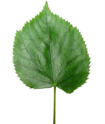
Tilia leaf
The example of a test of leaves was started on October 17 with the collection of 10 yellow fallen and 10 picked green Tilia leaves at Braintree (west of the southern end of New Street and fallen on to a parking lot). After five hours in a plastic bag they were floated in all the recently illustrated buckets and tanks of seawater. A brown set collected on January 30 2001 was dried between newspapers before being similarly tested 26 days later.
The sinking of these leaves in buckets and tanks did not appear to depend on water quality. It involved estimation of times when they sink in the night, or between observations. My method has been to stay up for the first and last sinkings of a set, if sinking looked eminent, and not worry too much if the sinkings around the average had to be roughly estimated. Usually I have studied undried leaves so I was not satisfied with the seven previous Tilia times from dried brown and decayed material. The results for the tree sets are as follows (latest at 15°C):
Brown (7) Av. 6.67 days (range 0.847-10.124)
Yellow (10) Av. 2.1165 days (range 0.811-6.679)
Green (10) Av. 2.178 days (range 1.654-2.694)
The average dimensions of the green set were 85.9 mm by 78.5 mm width on the leaf itself, and 126.8 mm inclusive of the peteole or stem. The largest actually sank fist and had corresponding dimension of 128 mm by 123 mm, and 175 mm total length. The yellow set provides a more natural sampling of the leaf fall and averaged 67.0 mm by 61.8 mm width, with a total length of 96.0 mm. The largest leaf was the last to sink, probably because the peteole was shorter than the penultimate sinking of one with the same overall length of 130 to 131 mm in 3.047 days. These two yellow leaves respectively measured 80 by 68 mm width and 93 by 74 mm width on the leaf itself. Where the leaf was longer on the sides than along the central vein I measured the later, and where damage to the tip had occurred I estimated this length. The damaged leaves actually had averaged times and were relatively small, but the two longer floating yellow leaves did look thinner and paler on the upper surface when finally dried-out.
Incidentally, I am not sure which species this downtown Braintree belongs too. Judging from the larger leaf size, it would be Tilia platyphyllos Scopoli; but the hairs on the lower side of the leaf were confined to vein branches as in the hybrid between it and the Nature north Essex Tilia cordata Miller, termed Common Lime or Tilia x europaea L. In Germany the genus in termed Linden and in eastern North America Basswood. But Linnaeus, probably following the Braintree/Notley resident John Ray, correctly identified it with Tilia of Virgil and Ovid. Presumably the downtown Braintree tree is not old or Native enough for Ray to have studied it himself.
Tilia platyphyllos

Tilia leaf

The example of a test of leaves was started on October 17 with the collection of 10 yellow fallen and 10 picked green Tilia leaves at Braintree (west of the southern end of New Street and fallen on to a parking lot). After five hours in a plastic bag they were floated in all the recently illustrated buckets and tanks of seawater. A brown set collected on January 30 2001 was dried between newspapers before being similarly tested 26 days later.
The sinking of these leaves in buckets and tanks did not appear to depend on water quality. It involved estimation of times when they sink in the night, or between observations. My method has been to stay up for the first and last sinkings of a set, if sinking looked eminent, and not worry too much if the sinkings around the average had to be roughly estimated. Usually I have studied undried leaves so I was not satisfied with the seven previous Tilia times from dried brown and decayed material. The results for the tree sets are as follows (latest at 15°C):
Brown (7) Av. 6.67 days (range 0.847-10.124)
Yellow (10) Av. 2.1165 days (range 0.811-6.679)
Green (10) Av. 2.178 days (range 1.654-2.694)
The average dimensions of the green set were 85.9 mm by 78.5 mm width on the leaf itself, and 126.8 mm inclusive of the peteole or stem. The largest actually sank fist and had corresponding dimension of 128 mm by 123 mm, and 175 mm total length. The yellow set provides a more natural sampling of the leaf fall and averaged 67.0 mm by 61.8 mm width, with a total length of 96.0 mm. The largest leaf was the last to sink, probably because the peteole was shorter than the penultimate sinking of one with the same overall length of 130 to 131 mm in 3.047 days. These two yellow leaves respectively measured 80 by 68 mm width and 93 by 74 mm width on the leaf itself. Where the leaf was longer on the sides than along the central vein I measured the later, and where damage to the tip had occurred I estimated this length. The damaged leaves actually had averaged times and were relatively small, but the two longer floating yellow leaves did look thinner and paler on the upper surface when finally dried-out.
Incidentally, I am not sure which species this downtown Braintree belongs too. Judging from the larger leaf size, it would be Tilia platyphyllos Scopoli; but the hairs on the lower side of the leaf were confined to vein branches as in the hybrid between it and the Nature north Essex Tilia cordata Miller, termed Common Lime or Tilia x europaea L. In Germany the genus in termed Linden and in eastern North America Basswood. But Linnaeus, probably following the Braintree/Notley resident John Ray, correctly identified it with Tilia of Virgil and Ovid. Presumably the downtown Braintree tree is not old or Native enough for Ray to have studied it himself.

Tilia platyphyllos
Thursday, November 02, 2006
Drifted L.E.C.A.
October 14 2006. The Light-weight Expanded Clay Aggregates (L.E.C.A.) found stranded on Chalkwell Beach on October 9 and sampled coming in with the tide at Westcliff the next day correspond to a sentence by G.C. Cadée in his article on Texel beaches in The Drifting Seed vol. 11 no. 2 p.5 (Sept. 2005) namely “building stones of this expanded clay are made and those much larger stones one can find also in drift on our beaches.” His report was mainly about 7 mm spheres found there, with yellowish surfaces around dark purple coloured shallow cracks. both were made by calcination of the middle London Clay Formation at 1200°C in the LECA (G.B.) pits and factory at Mill Lane, High Ongar, Essex c. 1968-1995. However they are potentially made from various clay sites around the world and I have assumed that the Ongar pits ran out of clay, at least from there. On taking both the drifted material and part of one currently being used on a building site to a builders merchant, I was informed that they are marketed as CELLON BLOCKS but not where they are currently made. They doubtless get put into the sea either by illegal flytippers, or as part of official dumping of hardcore to improve sea defenses, and then float away!! I had not noticed them before and initially assumed that Lower Greensand Cretaceous sandstone pebbles in the recently repaired seawall had already come loose. They might also be confused with concrete until picked-up and the following description is made here for beachcombers and geologists.
As seen on building sites the blocks are rectangular with a length around one foot or 30 cm (I am not sure exactly which; doubtless 30cm in the Netherlands) with easily broken edges showing a pitted, rather than actually porous, rough interior. Two colours were seen both on the beach and on house building sites at Southend-on-Sea this week. A dry inland fragment (110 by 85 by 60 mm) was light bluish grey (5B 6/1), changing on both the submerged and the emerged surfaces to dark bluish grey (5B 3/1) after about five hours in an oxygenated seawater tank. The other type is very light grey (N8) and represented by the sample taken from the sea (180 by 130 by 60 mm worn subtriangle) given a light greenish grey (5G 8/1) colour by a thin film of algae and having dark yellowish grey colour (5Y 7/1) on the less easily coated original surface of the block. The latter look very much like clay which has been cut and smeared by a spade or mechanical digger, while the rough surface of both colour varieties consists of rather square 0.5 to 0.8 mm wide pits, between thin walls of silty vitrified clay showing a few dark spots of what was once presumably pyrite. Perhaps the blue variety is a more originally pyritic clay, or more likely one processed in a more reducing environment. One of the yellowish blocks from the beach was placed in the deoxygenated seawater bucket for two days and seen to go uniformly dark bluish grey below the waterline. This stain differs from the hydrogen sulphide staining of the wood, bone and aragonite shells on Chalkwell foreshore in being entirely lost again when exposed to dry air overnight. Both varieties have 10 to 20% of the volume above the waterline and do not appear to be sinking like pumice initially does.
As seen on building sites the blocks are rectangular with a length around one foot or 30 cm (I am not sure exactly which; doubtless 30cm in the Netherlands) with easily broken edges showing a pitted, rather than actually porous, rough interior. Two colours were seen both on the beach and on house building sites at Southend-on-Sea this week. A dry inland fragment (110 by 85 by 60 mm) was light bluish grey (5B 6/1), changing on both the submerged and the emerged surfaces to dark bluish grey (5B 3/1) after about five hours in an oxygenated seawater tank. The other type is very light grey (N8) and represented by the sample taken from the sea (180 by 130 by 60 mm worn subtriangle) given a light greenish grey (5G 8/1) colour by a thin film of algae and having dark yellowish grey colour (5Y 7/1) on the less easily coated original surface of the block. The latter look very much like clay which has been cut and smeared by a spade or mechanical digger, while the rough surface of both colour varieties consists of rather square 0.5 to 0.8 mm wide pits, between thin walls of silty vitrified clay showing a few dark spots of what was once presumably pyrite. Perhaps the blue variety is a more originally pyritic clay, or more likely one processed in a more reducing environment. One of the yellowish blocks from the beach was placed in the deoxygenated seawater bucket for two days and seen to go uniformly dark bluish grey below the waterline. This stain differs from the hydrogen sulphide staining of the wood, bone and aragonite shells on Chalkwell foreshore in being entirely lost again when exposed to dry air overnight. Both varieties have 10 to 20% of the volume above the waterline and do not appear to be sinking like pumice initially does.
Weather records on London Clay subsidence 2006.
October 12 2006. The previously cited qualitative records of rain during this dry year on the London Clay illustrated (September 29 2006) can be compared to rain gauge records in decimal inches made by John Bird in his garden 0.35 km east of the photograph of Eastwood. Combined with my observations of when it rained during the day these diurnal totals can be put in order as a guide to likely flash floods in 2006:
Overnight April 9/10 0.78 (April total 1.54)
Rains until evening October 6 0.6 inch
Evening thunderstorm Sept 13 0.5 (Sept. total 1.04)
Overnight May 6/7 0.48 (May total 3.00)
Overnight Aug. 23/24 0.38 (Aug. tot. 2.10)
Continues daylight Aug. 23 0.38
Afternoon x later March 7 0.30 (March total 1.15)
Around 1hrs. G.M.T. August 17 0.23
Around 4 hrs. G.M.T. August 28 0.22
General “some rain” on June 15 0.22 (June total 0.73)
Rain x windy night Feb. 15 0.22 (Feb total 0.84)
It will be seen that much of the monthly rainfall took place on single days or nights, and often with most of it falling within an hour or so, in sudden bursts on a time-scale of a few minutes. This water then runs off the modern gardens converted into parking lots, decking and sheds, as well as roof areas, which were originally designed to similarly flood the street and sewers, not wet the subsoil. consequently most of the water forms a torrent down the street and a flash flood in the river despite improvements made to stop it overflooding the road seen in the photograph (which used to flood, but not now the river is in a deeper concrete channel). A more sustained gentle rain would have been better for reducing subsidence claims even in tradition gardens.
Looking now at the monthly rainfall totals from the same local source one needs to also consider when the hawthorn and other more substantial local trees developed leaves able to extract water from their tiny roots below dwellings (although the conifers, often more popular in gardens obviously operate all the year). The leaves have recently been falling in November and appear again in the middle of April (my diary notes April 14 2006 for a hawthorn, which I had fully removed because it was causing damage by September 10). It did not help that the first third of the year was also unusually dry (Jan. 0.68, Feb. 0.84, March 1.15), but there was some improvement in the spring (April 1.54, May 3.00) causing a large development of leaves, which partly became yellow and fell-off during the summer drought (June 0.73, July 0.29). Rain did return on August 12/13 but not in substantial amounts until the end of the month when it came in the potential flash floods recorded above (Aug. tot. 2.10, Sept. 1.04). These records are only up to October 11 but the present month is clearly relatively wet and the cracks in buildings are closing up. It is unavoidable that some trees have to be removed due to this type of dry weather and their proximity to dwellings with concrete foundations resting in the London Clay. However removal of all the trees from Essex, now increasingly covered in this way by dwellings and concrete, will contribute to climate change globally and to flash flooding locally.
In the longer-term the sea level and tidal range at Rochford will influence the ability of the river shown on the left of the photograph to discharge any rain which happens to fall when the tide is in. Before the late 18th Century there was no road there and it was termed a mead.
Stranded L.E.C.A. and apples
October 10 2006. The highest predicted tide at Chalkwell, not only this year but for several others, was yesterday afternoon at 3.4 m above mean sea level, and both tides on the 8th and the 13.35 G.M.T. tide today were predicted as 3.3 m. Presumably this is due to the unusual size and yellow appearance of the Harvest moon, which was so impressive at the end of last week. Also a quarter of an inch of rain fell locally on October 5. This resulting flash flood and high tides evidently a gravel ridge, capped with rolls of algae concentrated on the west sides of breakwaters, before the highest predicted tide arrived. This ridge did not look much different this morning. It had just gathered more algae, plus a new element, Sea Purslane leaves removed from upper beaches and marches by high tides. It was more instructive to observe much the same floating materials in today’s high tide before it could amalgamate them with less buoyant and older stranded material on the beach. The material actually seen coming in floating with the tide over a studied distance of 1.7 km were two brown oak leaves, 15 conspicuous feathers (mainly gulls up to 320 mm length, but including two of the banded ?Curlew feathers discussed previously of 225 mm length); large rafts of Sea Purslane leaves (Halimione portula coides (L.), which floated for 48.2 days when picked and tested in December 2000) and sea grass (Zosteras),this became more common towards Westcliff than the Sea Purslane presumably coming from Leigh March rather than intertidal sands); much large human wood debris evidently coming from a flooded café selling cockels, but perhaps not directly and a floating building stone discussed below and a few plastic bottles and drink cans. In addition there were a few floating sticks.
Below this level in the sea was a swash zone of non-buoyant material being suspended by the waves and moved on to the beach above even less buoyant strandline material such as stones and open bivalve shells (Mytilus x Mercenaria). The suspended material included one large and one small dead Common Crab (Carcirus), brown algae and other vegetation bound into rolls along the edge of the incoming tide, one or two brown leaves of genera other than oak, a cone of Pinus nigra and a cultivated apple. Neither of these floated when taken home and tested in more static seawater, although they appeared to do so due to the motion of the waves. Apples but not pine cones were also conspicuous on the gravel ridge made recently, as was the building stone debris. They are therefore reviewed here.
At first sight one assumes the brown and deplorable state of the apple is due to the work of the sea, and seabirds, while it was gradually becoming non-buoyant on the intertidal mudflats. However, both the pitting and brown to black external colouration matches an apple of the same size and shape picked from the wet soil inland today. They even turned brown when kept dry and away from Magpies, after a few days indoors; while these placed directly in seawater look unaltered and can float well (as do the brown previously decayed type). The drifted apple had an equatorial diameter of 55 mm and a height diameter of 42mm, on a short stalk. One side was black and crushed, and corresponded to the bruised zone caused by landing inland. Stranding in the swash before collection produced radial cracks, which lost air when refloated. The only significant differences between the two brown and pecked apples were seen after cutting in half. The stranded one had flesh of the same orange colour, which was firmer and non-buoyant in seawater, and the core lacked seeds. It was not clear why the seeds were missing although insect borings along the stem might have been missed in such a decayed structure. Clearly the stranded apple was a red to yellow variety of Malus domestica Borkhausen which is unlikely to have been sold to the English public in that state and probably came from rejected garden waste, or in a flash flood (they do float in tap water for over a day even when brown and from wet soil). Obviously the many apples seen on Southend beaches earlier in the year have just been rejected from lunch boxes, being out of season and quite undecayed. Tested Crab Apples float much less well and probably cannot reach the sea in rivers at all (see also photographs taken October 7th).
Coconuts and Pinecones
October 8 2006.
coconuts and pinecones
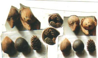
A second pair of photographs taken yesterday shows dried pinecones and coconuts at slightly different angles and illuminations. The bowl shows Pinus nigra cones dried-out after having sunk recently. The greater size of the now fully dry pinecone stranded at Chalkwell on April 7 2006 is illustrated by placing it beside them on the bottom left hand side of the four coconuts. Probably it is Pinus pinaster Aiton, with the apical scales fibrous and partly missing by the combined effects of maturation on the tree and beach erosion, prior to the final episode of marine transport from an unknown (English?) beach. Two of the coconuts also stranded in the Southend-on-Sea area, probably after being released into London canals for Hindu Rituals. The one on the top left stranded at Thorpe Bay during a S.W. gale at 16 hours. G.M.T. on January 13 2004, and shows a triangular mass of coir fibres truncated into a 10 mm diameter facet by Man rather than a natural erosive process in the Gulf Stream. It was then floated in the illustrated bucket, without drying during collection or major weight gains until it was removed on July 12 2006. During this time in the bucket the mass decreased from a maximum of about 806 g to about 673 g, and the orientation changed from coir-apex down to horizontal, presumably because the endosperm white flesh of the coconut gradually decayed. Certainly it now rattles about in this new even less dense dry state. One of the eyes was open enough for air bubbles to exit it when collected. An old water line in the bucket experiment can be hopefully seen on the photograph defined by a white band with a chord diameter of 80 mm on the opposite end of the nut from the coir fibres around the eyes. The overall length is 170 mm and the equatorial diameter 110 mm.
The stranded coconut on the top right is the one discussed on this blog and was found near Chalkwell Shelter on April 2 2006, with the husk separated and one of the eyes which had been covered by it seen to have a tunnel of white endosperm below it. In this case the husk looks more extensive than that seen usually on sale in England.; but might presumably have been imported for a Hindu niche market. I wish I knew exactly how Hindu’s prepare their coconuts for ritual refloatations and when. The usually cited and observed canal and coastal rituals are roughly in August and not when I see strandings at Southend. Natural drifting with the Gulf Stream is possible but would seem likely to produce more evidence of marine encrustation. Illustrations of stranded coconuts at intermediate sites would be instructive if they show what form the husk has after being floated by hurricanes etc.
The two lower coconuts were purchased from an English supermarket, where they are sold with less husk present than in some Green grocers shops. They are coconuts A (left) and B (right) of my notes in The Drifted Seed 2005 and 2006. The photograph is mainly of interest in showing that coconut B has become black during a second summer of drying after having sunk in seawater. The other coconut A shows the colouration after drying for just one summer and when any coconut has been in seawater for a day or so it is dark brown. In terms of mass changes in coconut B, there was an increase from about 550 g when purchases., to 620 g just after it sank and 644 g when drying started on day 626 of the experiment. Dehydration and perhaps some decay reduced the mass to 339 g on day 802; but after the nut became black again and leaked green copra oil from the eye the mass was further reduced to 259 g on day 1100 (which was just prior to the photography). Curiously when half-coconuts are left exposed to the air and not eaten by birds the flesh seems relatively stable at English temperatures.

coconuts and pinecones
A second pair of photographs taken yesterday shows dried pinecones and coconuts at slightly different angles and illuminations. The bowl shows Pinus nigra cones dried-out after having sunk recently. The greater size of the now fully dry pinecone stranded at Chalkwell on April 7 2006 is illustrated by placing it beside them on the bottom left hand side of the four coconuts. Probably it is Pinus pinaster Aiton, with the apical scales fibrous and partly missing by the combined effects of maturation on the tree and beach erosion, prior to the final episode of marine transport from an unknown (English?) beach. Two of the coconuts also stranded in the Southend-on-Sea area, probably after being released into London canals for Hindu Rituals. The one on the top left stranded at Thorpe Bay during a S.W. gale at 16 hours. G.M.T. on January 13 2004, and shows a triangular mass of coir fibres truncated into a 10 mm diameter facet by Man rather than a natural erosive process in the Gulf Stream. It was then floated in the illustrated bucket, without drying during collection or major weight gains until it was removed on July 12 2006. During this time in the bucket the mass decreased from a maximum of about 806 g to about 673 g, and the orientation changed from coir-apex down to horizontal, presumably because the endosperm white flesh of the coconut gradually decayed. Certainly it now rattles about in this new even less dense dry state. One of the eyes was open enough for air bubbles to exit it when collected. An old water line in the bucket experiment can be hopefully seen on the photograph defined by a white band with a chord diameter of 80 mm on the opposite end of the nut from the coir fibres around the eyes. The overall length is 170 mm and the equatorial diameter 110 mm.
The stranded coconut on the top right is the one discussed on this blog and was found near Chalkwell Shelter on April 2 2006, with the husk separated and one of the eyes which had been covered by it seen to have a tunnel of white endosperm below it. In this case the husk looks more extensive than that seen usually on sale in England.; but might presumably have been imported for a Hindu niche market. I wish I knew exactly how Hindu’s prepare their coconuts for ritual refloatations and when. The usually cited and observed canal and coastal rituals are roughly in August and not when I see strandings at Southend. Natural drifting with the Gulf Stream is possible but would seem likely to produce more evidence of marine encrustation. Illustrations of stranded coconuts at intermediate sites would be instructive if they show what form the husk has after being floated by hurricanes etc.
The two lower coconuts were purchased from an English supermarket, where they are sold with less husk present than in some Green grocers shops. They are coconuts A (left) and B (right) of my notes in The Drifted Seed 2005 and 2006. The photograph is mainly of interest in showing that coconut B has become black during a second summer of drying after having sunk in seawater. The other coconut A shows the colouration after drying for just one summer and when any coconut has been in seawater for a day or so it is dark brown. In terms of mass changes in coconut B, there was an increase from about 550 g when purchases., to 620 g just after it sank and 644 g when drying started on day 626 of the experiment. Dehydration and perhaps some decay reduced the mass to 339 g on day 802; but after the nut became black again and leaked green copra oil from the eye the mass was further reduced to 259 g on day 1100 (which was just prior to the photography). Curiously when half-coconuts are left exposed to the air and not eaten by birds the flesh seems relatively stable at English temperatures.
Saturday, October 21, 2006
Various buckets and tanks
October 7 2006. Photograph the various buckets and tanks used for floatation in seawater experiments and also the now dry coconuts and pinecones. Various items and topics are reviewed here. In experiments involving fruit and wood a white bacterial film grows on the surface of the water and these objects even with frequent aerations or exchanges with new seawater. Probably sugar solutions exit the fruit and feed the bacteria, which then deoxygenate the water if they die and sink to the bottom. In addition materials such as wood and pinecones eventually stain the water brown and also make it form a foam when shaken-up, which then inhibits oxygenation. One pair of photographs, in different lighting conditions, shows a relatively new seawater on the left with apples in it and an older seawater with only less active materials present since this right-hand water was previously used to float apples and has been stained slightly brown by the pinecones.
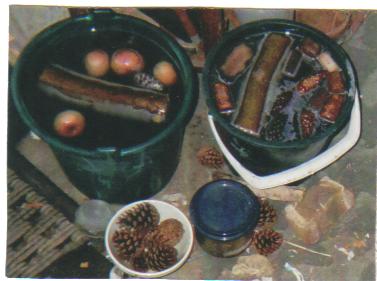
two pails
In it there is a greater quantity of white bacteria present. What is odd is that only the nearly emergent tops of these and other pinecones are stained white while it is the submerged upper parts of the wood and apples, which develop this white film. To some extent it just defines a waterline on inert materials, such as the plastic bucket and floating coconuts; but on the cones it also extends higher than this level film. Consequently when coconuts are removed and dried one can see a waterline of white or grey bacterial and algal staining present where they spent most of their time floating, and this also provides clues in Nature about drifting orientations on shells since I have recently cut some wood in the garden, due to the drought/subsidence problem outlined previously. It was interesting to compare the densities of instantaneously cut and floated wood in their summer state of moisture. Hawthorne logs sank straight away in seawater, but samples left ash cut ends on the tree before further cutting sometimes floated for a few minutes. Elder wood generally sank instantaneous but a few samples did float without drying, but only for a few days. When that is the case then longer sections of wood, termed logs, float longer than slices cut from between them, due to rates of water and air inside the structure being involved. Also as one moves from the stem to the thin twigs, even of Hawthorne, the floatation times increase, presumably because the new wood is less dense. Thus when one considers a less dense wood such as Ash, the twigs can float longer than the logs because they are initially less dense and more liable to dry if left on the ground. On the other hand the logs float longer than smaller slices of the same density and some twigs, due to rates of waterlogging and decay being increased when the surface to volume ratio is larger in a smaller structure. In a further complication seasonal variations in moisture change both the initial density and the rates of waterlogging. The photograph shows two logs of an Ash Fraxinus still floating after 7 days, compared to one and two days for the wood slices of 10 to 20mm length which were cut off them before floatation.
2 pails
The logs have a length around 195 mm and diameters around 65 mm, representing the base of a major twenty-year old branch. Judging from previous tests done at this time of year on an adjacent branch these logs may only float in these buckets until November, while the record for Ash twigs is held by one cut in November 30 2000 that sank after 276 days (diameter 19mm, cut to 74 mm length and kept in plastic bag until floated December 16 2000).
The associated floating objects in the left hand bucket are four apples of Malus domestica Borkhausen which fell from the tree and were floated in the morning of September 8 2006 (out of a sample of 10, 4 have sunk, 2 others float in another container), a wine cork made from Quercus suber L. which has nearly sunk after being floated on March 12 2001 (it can hardly be seen in the photograph, being tilted up and almost submerged) and the last of a batch of 8 Pinus nigra Arnold cones collected and floated on September 11 2006. The other bucket shows some driftwood, stranded corks and more recently collected cones from below the same tree. The record from Pinus nigra cones from that tree is currently held by two that fell in winter and floated for 65 days after January 7 2002. This is somewhat mysterious since drier; more open summer cones might be expected to float longer. Colder experimental conditions in winter and the larger size of the cones available that day probably explain that anomaly.

two pails
In it there is a greater quantity of white bacteria present. What is odd is that only the nearly emergent tops of these and other pinecones are stained white while it is the submerged upper parts of the wood and apples, which develop this white film. To some extent it just defines a waterline on inert materials, such as the plastic bucket and floating coconuts; but on the cones it also extends higher than this level film. Consequently when coconuts are removed and dried one can see a waterline of white or grey bacterial and algal staining present where they spent most of their time floating, and this also provides clues in Nature about drifting orientations on shells since I have recently cut some wood in the garden, due to the drought/subsidence problem outlined previously. It was interesting to compare the densities of instantaneously cut and floated wood in their summer state of moisture. Hawthorne logs sank straight away in seawater, but samples left ash cut ends on the tree before further cutting sometimes floated for a few minutes. Elder wood generally sank instantaneous but a few samples did float without drying, but only for a few days. When that is the case then longer sections of wood, termed logs, float longer than slices cut from between them, due to rates of water and air inside the structure being involved. Also as one moves from the stem to the thin twigs, even of Hawthorne, the floatation times increase, presumably because the new wood is less dense. Thus when one considers a less dense wood such as Ash, the twigs can float longer than the logs because they are initially less dense and more liable to dry if left on the ground. On the other hand the logs float longer than smaller slices of the same density and some twigs, due to rates of waterlogging and decay being increased when the surface to volume ratio is larger in a smaller structure. In a further complication seasonal variations in moisture change both the initial density and the rates of waterlogging. The photograph shows two logs of an Ash Fraxinus still floating after 7 days, compared to one and two days for the wood slices of 10 to 20mm length which were cut off them before floatation.

2 pails
The logs have a length around 195 mm and diameters around 65 mm, representing the base of a major twenty-year old branch. Judging from previous tests done at this time of year on an adjacent branch these logs may only float in these buckets until November, while the record for Ash twigs is held by one cut in November 30 2000 that sank after 276 days (diameter 19mm, cut to 74 mm length and kept in plastic bag until floated December 16 2000).
The associated floating objects in the left hand bucket are four apples of Malus domestica Borkhausen which fell from the tree and were floated in the morning of September 8 2006 (out of a sample of 10, 4 have sunk, 2 others float in another container), a wine cork made from Quercus suber L. which has nearly sunk after being floated on March 12 2001 (it can hardly be seen in the photograph, being tilted up and almost submerged) and the last of a batch of 8 Pinus nigra Arnold cones collected and floated on September 11 2006. The other bucket shows some driftwood, stranded corks and more recently collected cones from below the same tree. The record from Pinus nigra cones from that tree is currently held by two that fell in winter and floated for 65 days after January 7 2002. This is somewhat mysterious since drier; more open summer cones might be expected to float longer. Colder experimental conditions in winter and the larger size of the cones available that day probably explain that anomaly.
Friday, October 06, 2006
London Clay and climate change
September 29 2006. My diary lists the following dates when rain wetted my garden this year in the rain shadow of the Rayleigh Hills, Essex.
February 12 and particularly 15th.
March 7, 10 and 24 (minor events).
April 1-2 heavy, but short showers.
April 10 extensive rain.
May 14, 16, 20, 22 and 25 (20th and 25th extensive).
May 26, 27, 29, 30 (minor events).
June 13, 14, 15, 21 (minor events).
June 26 extensive rain.
July 5 heavy but short shower.
July 7,9,11, and 22, August 1 and 7 (minor events).
August 13 finally have significant rain.
August 17 extensive rain (minor on 21st).
August 23-24 extensive rain (minor on 26th).
August 28 extensive (minor on Sept 1st).
September 13 extensive rain.
September 22 short heavy shower.
Essex Radio had a program earlier in the week on the subsidence caused by tree roots dehydrating the London Clay terrain in southern Essex this summer. More sandy substrates do not subside in this way but during wetter years, particularly winters when the deciduous trees are not extracting water in this way; they produce springs and slumps at the junction with the London Clay. Presumably having minor sand or silt layers within the London Clay itself has the dual effect of producing a slightly steeper, stronger slope below the dwellings, and a route for tree roots to extract water from the interbedded clays in a dry summer. The tendency to cover Essex with buildings and parking lots, rather than gardens, is encouraged by insurance companies faced with subsidence claims. This in turn reduces the ability of water to wet the subsoil rather than run off down the road, drains rivers and into the sea in a few hours. During wetter weather this rapid exit of the water itself causes problems for property owners living near rivers which cannot hold the increased water supply, often supplied in short thunder storms and a flash flood. Given a larger slope with London Clay below sands or natural streams one can observe major slumps such as the Southend Bandstand visited on May 10.
Southend Bandstand - major slump of London Clay
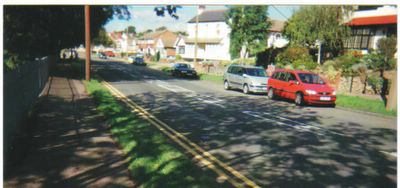
London Clay drainage problems, Southend-on-Sea. London Clay slope opposite a river liable to flash flooding along its new concrete channel (below railings on left). Also shows a continuous spring-line above the opposite sidewalk (red warning signs behind cars) apparently from a sandy layer with the London Clay. The finer laminated clays and septaria of the Beaver Tower bed occur below it and reach the sidewalk beside the white car (5th from right). After rain the water exits about one metre up the traditional garden paths in the middle of the photograph.
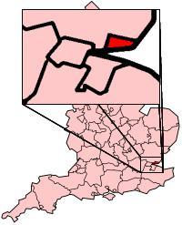
Map showing Southend England.
Cuttlebone flotation times
September 26 2006. Between 6.10 and 6.20 hrs. G.M.T. the last of the 25 cuttlebones found and refloated without drying in March 24 to April 3 sank in the seawater tanks. A few 10 mm long fragments of reed collected with them have remained floating, although many hundreds sank within a few days. Data for the Whelk egg cases also stranded around that time showed no correlation with their size and a wide variation on a shorter time-scale (e.g. 12 ranged from 1.6 to 54.65 days, with an average of 38.0 days). Intact cuttlebones of the same species and morphology would be expected to show a linear correlation between floatation time and length, due to the volume of gas being extracted and replaced by seawater via the porous surface area of the striated ventral chamber openings. Judging from results in my article in The Drifting Seed (2006) a large cuttlebone from the North Sea floats for four years in the test conditions reviewed here and the small shells stranded in March might float for one year or more. However, these predictions are modified by breakage and puncturing of the shells by fulmars presumably while the shell is still associated with the floating corpse of this squid-like animal. Moreover, some water is present inside the shell in life and more soon enters when they are punctured before stranding on an uncertain time-scale. Finally on arrival on the beach the shells tend to break in half and undergo further damage which makes them non-buoyant within a few days. Nonetheless the experimental floatation time is instructive as a guide to the possible transatlantic dispersal of these shells after death and presents some statistical problems due to the wide variation in observed times. In the latest test the original size of the shells is evident from their width, inclusive of their chitinous margin when intact and only ranged from 22 to 39 mm (Av. 30.4). The preserved length of these shells with a probable original length of up to 100 mm averaged 62.7 mm and the ratio of it divided by the with was more proportional to the floatation time than the absolute preserved length ranging from 35 mm (sank 14.4 days) to 96 mm (sank 122.4 days). However, the correlation was still poor, probably because the birds produced many deep punctures in some shells without breaking them. Since the sample was 25 one can remove the median result of 107.3 days, corresponding to the average of 91.0 days, and consider the averages and range in four subsets of six shells. The rapidly sunk set ranged from about 4.6 to 24.0 days (i.e. when they sank in the night, the time was recorded half-way through it) with a mean of 11.7 days and a length/width ratio averaging 1.89 to one. The next six averaged 44.5 days and 1.92 to one. The next six with times greater than the median sample averaged 128.8 days and 2.32 to one, mainly because they were more intact. Finally the six with the longest times, ranging from about 158.1 to 185.4 days average 176.5 days and a length ratio of 2.44 to one. Overall the average floatation time of 91.0 days occupied a rather rare period in a polymodal distribution with the four sunk between 182.2 and 185.4 days perhaps close to the limit for these damaged small cuttlebones?
a cuttlefish
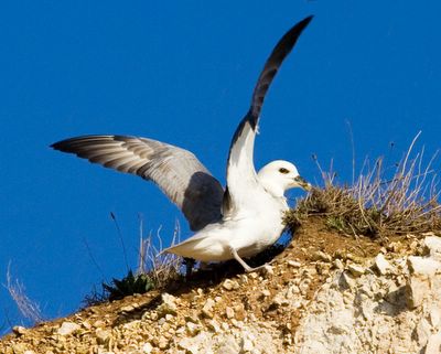
Northern Fulmar (Fulmarus glacialis) landing on a cliff top at Hunstanton, Norfork, England. Photograph copyrighted Andrew Dunn, 18 February 2006 (http://www.andrewdunnphoto.com). This file is licensed under Creative Commons Attribution ShareAlike 2.0 License

a cuttlefish

Northern Fulmar (Fulmarus glacialis) landing on a cliff top at Hunstanton, Norfork, England. Photograph copyrighted Andrew Dunn, 18 February 2006 (http://www.andrewdunnphoto.com). This file is licensed under Creative Commons Attribution ShareAlike 2.0 License
Tuesday, September 26, 2006
Resurfacing of coconuts
Coconut I of my experimental floatations in seawater was marketed, wrapped in plastic, as a “Milky Coconut, Dominican Republic 5711/03 class 1, display until February 8 2005”. The initial mass, inclusive of subsequently removed plastic and coir fibres was 605 g and sank in seawater in February 1 2005 at 15.30 hrs G.M.T. During the first two and a quarter hours air bubbles effused from around two of the three eyes (basal pores) when the coconut was manually inverted from the usual apex-up orientation when sinking. This air presumably came from the nut wall, via canals seen radiating from the inside of the basal pores on split specimens, since the nut exterior changed from light to dark brown in this short time. A wet mass, exclusive of removed coir fibres and plastic was recorded as 607 g after exactly 2.3 of a day in the seawater tank, rising to 611 g on days 2.6 and 11.8. After this the coconut was removed to the bottom of an open bucket used to house the rejected old tank seawater and had a mass of 607 g on day 100, 601 g on day 127 and 598 g on day 200. This water sometimes had a raised density due to evaporation before being exchanged with new water from the sea and this was 1.032 g/ml on day 575 when coconut finally had lost enough internal mass of endosperm and or milky liquid to resurface. It was then returned to the diurnally aerated tank seawater of 1.029 g/ml density where it promptly sank at a mass around 586 g. The displacement volume found by dividing this mass by the density of the two seawaters was therefore 567 to 568 ml, and the initial density when marketed 1.06 g/ml. The cited water densities are from a hydrometer only giving an exact reading at 20°C and actually recorded at 6 hrs G.M.T. on August 31 2006 at 16°C. The air temperature above the bucket had risen to above 77°F (25°C) in the later July 2006 heatwave without causing the coconut to resurface. This suggests that expansion of primary and secondary decay gases by increased ambient temperature is not the direct cause of resurfacing during a relatively cool weather. Probably the high temperatures increased the rate at which the milky liquid and endosperm inside the nut was converted into gas, but due to the still intact nature of the three basal pores and nut wall the gases merely diffused out if their partial pressures were greatly in excess of the ambient and similarly stagnate seawater. In previous experiments, reported from the fresher tank seawater in my articles in The Drifting Seed (2005, 2006) the initially more buoyant coconuts A to F all became gradually less dense during the first 200days of flotation and only then started to gain mass due to a net replacement of their internal primary and secondary gases by seawater. Coconut I is merely following the same trend but on a longer time-scale and with little or no primary air present inside the endosperm cavity when marketed. Some of these coconuts contained little or no milky liquid when marketed and evidence of loss of endosperm flesh under the basal pores before the latter became thin or open enough to admit seawater at an increasing rate in the aerated tank environment. Probably there is a similar decay of endosperm flesh into bacteria plus gas going on to reduce the mass of coconut I, and not merely fermentation of milky liquid which may have actually slowed the decay process in the denser endosperm down? It is predicted that coconut I, now kept in the aerated tank environment will soon resurface due to further internal mass loss.
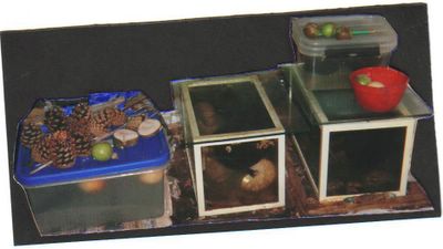
My tanks.

My tanks.
Wednesday, September 20, 2006
Chalkwell Stranded feathers (cont.)
September 3 and 4 2006. Chalkwell beach was revisited around noon on both these days, with predicted tides at 1.6 m above mean sea level forming a strandline of eelgrass (Zostera), brown algae and gull feather on the first morning and cut into a small cliff on the second morning. There was a southwest gale on September 2 and 3 but it was calm at the times of the high tides. The occurrence of eelgrass was a new feature, not very evident earlier in the year and doubtless resulting from the wind acting on the lower intertidal zone, about 2 km south-west of Chalkwell, where this marine grass grows in summer.
On September 3 a couple of hundred metres of the strandline showed three large bird corpses, as well as the separated barred and gull feathers seen previously. A large gull with intact head had stranded against the west side of a breakwater and two headless birds were on the open strandline further to the east. The large gull probably corresponded to the feathers of the Lesser Black-Backed Gull now added to the loose assemblage and one of the corpses was a white smaller gull represented by loose Black-Headed Gull feathers seen previously. Both these corpses had gone the next day but the third one remained having merely been displaced down the cliff of grass and sand cut by the later tide and wind. During this displacement one of the wings had opened but considerable force was required to pull out one of the primary feather of around 320 mm when standing on the corpse. This feather was dark grey with a white rhachis. This feather was not greatly different to those found loose and attributed to the wings of Lesser Black-Backed Gulls, and the smaller transverse banded brest and tail feathers match the loose banded feathers found on August 22 and later. The secondary wing feathers were paler brown, with a white tip to the more blunt tip to the vane. Due to the ongoing bird influenza cares I did not make a more careful study of the corpse and these smaller feathers but judging from the size of the largest wing feathers it is more likely to be a Peregrine Falcon than a Cuckoo, and was clearly different from the colour pattern of a Curlew. However, a Curlew option for the loose banded feathers seen on the beach was reinforced by a collection of probable primary wing feather among the gull and banded feathers on September 4. This feather showed 14 brown triangular bars on the vane and an overall length of 231 mm. Probably it is a mistake to regard the new corpse with small banded feathers on the body as the only or even the main species yielding the small Curlew-like feathers on the strandline.
Black-Headed Gull
On September 3 a couple of hundred metres of the strandline showed three large bird corpses, as well as the separated barred and gull feathers seen previously. A large gull with intact head had stranded against the west side of a breakwater and two headless birds were on the open strandline further to the east. The large gull probably corresponded to the feathers of the Lesser Black-Backed Gull now added to the loose assemblage and one of the corpses was a white smaller gull represented by loose Black-Headed Gull feathers seen previously. Both these corpses had gone the next day but the third one remained having merely been displaced down the cliff of grass and sand cut by the later tide and wind. During this displacement one of the wings had opened but considerable force was required to pull out one of the primary feather of around 320 mm when standing on the corpse. This feather was dark grey with a white rhachis. This feather was not greatly different to those found loose and attributed to the wings of Lesser Black-Backed Gulls, and the smaller transverse banded brest and tail feathers match the loose banded feathers found on August 22 and later. The secondary wing feathers were paler brown, with a white tip to the more blunt tip to the vane. Due to the ongoing bird influenza cares I did not make a more careful study of the corpse and these smaller feathers but judging from the size of the largest wing feathers it is more likely to be a Peregrine Falcon than a Cuckoo, and was clearly different from the colour pattern of a Curlew. However, a Curlew option for the loose banded feathers seen on the beach was reinforced by a collection of probable primary wing feather among the gull and banded feathers on September 4. This feather showed 14 brown triangular bars on the vane and an overall length of 231 mm. Probably it is a mistake to regard the new corpse with small banded feathers on the body as the only or even the main species yielding the small Curlew-like feathers on the strandline.

Black-Headed Gull
Tuesday, September 05, 2006
Stranding of feathers at Chalkwell
August 22 2006. A further survey of the two latest strandlines between Chalkwell station and Shelter (0.6 km) showed a return to winter debris in the form of the brown alga Ascophyllum among the summer green algae. A few large common crabs were present, a large one with legs stranded dorsal-up and more numerous separated dorsal carapaces stranded ventral-up; concave-up in terms of hydrodynamics. There were also some stranded reeds, twigs and human-worked wood debris, which had not come directly from the marshes as the latest tides were all relatively low (predicted as slightly higher, 2.5 m above mean sea-level in latest tide studies around 1 p.m.). A characteristic feature of August strandlines was evident in the form of abundant adult feathers of Black-Headed Gulls, which were also seen alive and well on the beach, and locally molt at this time. My experience is that when floated in closed plastic bottles of seawater they remain largely intact and still do not sink (since August 9 1999, molted on grass inland at Leigh-on-Sea) but in more agitated and open tanks they soon break-up releasing separated calamus, rhachis and vane fragments which can sink despite initially being hollow and full of air. On December 4 2005 I refloated both dried and recently stranded primary wing feathers of the Great Black-Backed Gull Larus marinus L, mainly cut into the calamus (quill) and the remaining rhachis plus vane, in the diurnally agitated seawater tanks. The six calamus sample had cut dimensions of 145 mm boy 6 mm diameter, and their separated vanes had lengths ranging from 213 to 247 mm. Recently a few of the calamus samples have sunk apparently unchanged, while the others have lost all or most of their vanes and distal rhachis before sinking. By August 30, day 269 of floatation in the more open conditions there were just two calamus samples still floating horizontally, with one uncut feather which is not reduced to a total length of 350 mm lacking any trace of a vane and the tip of the rhachis. By contrast the black cormorant tail feather, stranded and refloated in the same experimental conditions on January 3 2006, sank in a macroscopically intact condition on August 4 (day 212). The black melanin probably resists decay and brittleness of the white keratin, but there is probably a better adaptation of the deep-diving feathers of cormorants against waterlogging. In addition they have a greater initial density, making them sink quicker when refloated than the relatively hollow structure of gull and other more typical bird feathers. This denser structure and the melanin doubtless contributes to their lower rate of decay, which in gull feathers is due to brittle fracturing of the keratin, rather than obvious bacterial growth. However it is also possible that cormorant feathers also contain more wax or oils than gull feathers. One can of course see the cormorants standing with their wings open to dry them while the gulls and other marine birds do not bother and are much better fliers despite this careless indifference to feather drying. Terrestrial birds even go to the trouble of getting their feathers wet in freshwater, rather than worry about his effect on wing density after a bath.
The more unusual and attractive feathers seen stranded on August 22 have continued to float in the same tank until August 30 without showing signs of damage. A sample of 8, with lengths of 116 to 131 mm and vane widths of 18 to 38 mm (when dry), showed the common characteristics of 8 to 12 transverse brown bands or triangular bars on the generally white background of the vane. The calamus and rhachis were mainly white, but with a grey more translucent proximal end to the calamus, and a shore central band of brown within the white proximal end of the rhachis. It was not clear to me what these feathers were, but since they were spread out on two adjacent strandlines over a 0.6 km distance they did not result from a single drowned woodpecker or similar non-marine species. The tail and secondary wing feathers of a local wading bird the Curlew Numenius arquata (L.) seem to be the most likely candidate judging from Tracks and Signs of the Birds of Britain and Europe by Brown et al. (2003, Christoper Helm, Publisher London 333 pp.). The main problem with that identification is that the similar-looking, larger primary wing feathers, were not seen among the gull feathers of that size; perhaps because they are not molted at the same time as the secondary and tail feathers.
Incidentally the two large pinecones floated and described on April 7 2006, also sank on the tank containing the gull calamus samples on August 2-4 after slight cooling of the warm seawater.
Thursday, August 10, 2006
July 5 2006. The predicted tide at 1.8 m above mean sea level was studied at Westcliff during a rare morning of showers this summer. Green algae defined the strandline, rather than brown algae as in April, and there were more numerous dead crabs stranded with it. Seven were counted as white juveniles with a ventral-up orientation and five were larger green specimens with a dorsal-up orientation, of the same species Carcinus maenus L. Their legs were still present and there was no obvious cause of death, but they were not just molted carapaces. Mytilus or mussel shells were present on the strandline as clean single valves, but an oyster shell had evidently arrived with the muscle still holding the valves together in an otherwise empty shell cavity. The two valves must have then become separated by the breaking waves, being found three metres apart and then fitted back together. Most of the surfaces of both valves were encrusted with long-dead barnacles lacking their central plates. But since the winter a clean new layer of marginal growth of the oyster had been disfigured by tiny spots consisting of nearly microscopic new and intact barnacles. Gull feathers, a few twigs, a wine cork and a pinecone with algae and a flint trapped in it were the only other stranded objects seen in a quick 1 km survey of the new strandline.
Since it was found the pinecone, probably Pinus nigra Arnold from Westcliff seafront gardens, was studied with other in warm sea water and dry sunny weather. When found it looked remarkably dry despite having a position on the latest strandline, collected in damp weather. The scales firmly held a white angular flint of orthogonal dimensions 9.1 by 8.0 by 7.1 mm which had not come from the same strandline.
July 20 2006. Another Westcliff beach survey, was done over a shorter interval of 0.7 km was done on the strandline produced by the predicted tide at 2.1 m above mean sea level (9am B.S.T. studied two hours later during a day of record high temperatures, which were less extreme by a still cool sea). Green algae again dominated the strandline showing a single large Common jellyfish and an intact but spineless regular echinoid (31.8 mm diameter, 23.5 mm high with less green side less convex). Crabs were present and were larger than on July 5 and there were also two pathetic stranded gulls, with enough vitality to turn their heads and body axes parallel to and just below the line of algae. Stranded dying gulls can also be seen in winter but are not often noted and they suggest that some environmental change has taken place in the warm weather.
July 27 2006. The two large pinecones floated in seawater and described on April 7 are still floating after 111 days but smaller cones sink faster in the same tanks. For example the cone with a flint in it was dried in the present warm and dry weather on July 17 at a length of 59.4 mm and a maximum diameter of 54.9 by 57.9 mm. The flint was placed on the upper surface and was firmly held by the contraction of the scales between 10 and 20 minutes later. Full contraction of the scales, to a stable diameter away from the flint obstructing the scales of 31.9 mm, took three and a half hours. Further waterlogging sank and cone plus flint after only about 9.7 days. The diameters of 29.6 mm by 31.3 mm away from the flint corresponded to a wet length of 6.48 mm. It was then place outside in the sun at 8.10 hrs B.S.T. on July 26. The scales opened enough to release the flint (54.1 by 50.8 mm) at 14.30 hours today.
Thursday, July 13, 2006
June 24 2006. Continuation of reading following the visit to Ingatestone (mainly Reaney’s Place Names of Essex Cambridge University Press 1969) indicates that it is situated in that part of the East Saxon Kingdom which became Chelmsford Hundred, extending along the Roman Road from London to Braintree and Bury St. Edmunds, from the crossing of the River Wid 20 and half English miles from London, to less obviously defined wooded backcountry now termed Young’s End nearly at the 38th mile post. In other directions the hundred was not extensive, but did join the probably originally superior Rochford Hundred at the old crossings of the Crouch estuary at Hull and Battlesbridges.
Ingatestone Parish Church is one of the few situated near this route in Essex and like other exceptions is probably a late addition to East Saxon settlement which avoided Roman roads and former settlements. Later extensions of these villages around old church sites are a mile or more away on the redeveloped Roman Road and given names such as Margasetting Street, the Street in Little Waltham etc. New market towns like Chelmsford and Braintree had the original church off the road. The new Braintree church was built on the Roman settlement and directly in line with the road. It has a glacial erratic boulder incorporated into a tower built after the market opened in 1199. Widford is another church on the road. The building has apparently been even more extensively “restored”, like the rest of the exterior walls at Braintree. At Ingatestone the erratic boulder was left in the churchyard, and not reused. At the time of the Domesday Survey the name Inge was sufficient for the manors most adjacent to the stone, and the previous extended moot area given allied names later such as Mountnessing (Ginga in 1087) and Margaretting (Ginga). However, when one of the central but secular manors of Inge had a second St. Mary’s Church built on it, probably at the same time as the present c.1100 Ingatestone Church exterior, it was obviously helpful to refer to the original site where rents were paid to the nuns as Inge at the Stone. Later when King Henry II gave the other old St. Mary’s Church to Friars of Jerusalem Hospital, it became Frierning. The first known use of the name Ingatestone was therefore after the arrival of the Friars, when it was recorded as the nuns’ property Ginges ad Petram in 1254. Having gone over much of the ground himself, R. Reaney goes with Morant and the consensus and rejects the idea which he credits to the 1913 book by Wilde and Christie, linking to stone to some hypothetical Roman milestone, rather than the more conspicuous erratic stone still in the churchyard. Probably the ancient Saxons knew nothing about Roman milestones and very little about their roads, but did find the erratic a convenient marker for meetings along the old track. What has undermined this interpretation has been the previous emphasis on the erratic also being used as a milestone by the Romans. This seems highly unlikely even though their mark would have been 30 yards beyond it if they wished to indicate 25 Roman miles from London along the route surveyed for the 18th Century 22nd milestone.
Ingatestone Parish Church is one of the few situated near this route in Essex and like other exceptions is probably a late addition to East Saxon settlement which avoided Roman roads and former settlements. Later extensions of these villages around old church sites are a mile or more away on the redeveloped Roman Road and given names such as Margasetting Street, the Street in Little Waltham etc. New market towns like Chelmsford and Braintree had the original church off the road. The new Braintree church was built on the Roman settlement and directly in line with the road. It has a glacial erratic boulder incorporated into a tower built after the market opened in 1199. Widford is another church on the road. The building has apparently been even more extensively “restored”, like the rest of the exterior walls at Braintree. At Ingatestone the erratic boulder was left in the churchyard, and not reused. At the time of the Domesday Survey the name Inge was sufficient for the manors most adjacent to the stone, and the previous extended moot area given allied names later such as Mountnessing (Ginga in 1087) and Margaretting (Ginga). However, when one of the central but secular manors of Inge had a second St. Mary’s Church built on it, probably at the same time as the present c.1100 Ingatestone Church exterior, it was obviously helpful to refer to the original site where rents were paid to the nuns as Inge at the Stone. Later when King Henry II gave the other old St. Mary’s Church to Friars of Jerusalem Hospital, it became Frierning. The first known use of the name Ingatestone was therefore after the arrival of the Friars, when it was recorded as the nuns’ property Ginges ad Petram in 1254. Having gone over much of the ground himself, R. Reaney goes with Morant and the consensus and rejects the idea which he credits to the 1913 book by Wilde and Christie, linking to stone to some hypothetical Roman milestone, rather than the more conspicuous erratic stone still in the churchyard. Probably the ancient Saxons knew nothing about Roman milestones and very little about their roads, but did find the erratic a convenient marker for meetings along the old track. What has undermined this interpretation has been the previous emphasis on the erratic also being used as a milestone by the Romans. This seems highly unlikely even though their mark would have been 30 yards beyond it if they wished to indicate 25 Roman miles from London along the route surveyed for the 18th Century 22nd milestone.
Wednesday, July 12, 2006
June 20 2006. Sand sampled from around the 85 m above mean sea level in S.E. Mill Green Common, uppermost Claygate Member on the Geological Survey maps, did not look much like that Eocene marine sand, being angular with many sharp edges at 0.08 mm diameter and mixed with only few well rounded 0.14 mm grains familiar to me from the Claygates elsewhere. In addition there were varied pebbles and even an angular cobble, with the same orange sand inside their pitting and presumably moved down the hill from the mapped area of the Old Head Gravels (which should have a clay matrix). I was, however, mainly interested in what the local pebbles looked like and made the following observations:
a) Angular flint cobble. The cobble did not look like a flint to me until I broke it open to show a conchoidal fracture of dark grey (N3) to brownish grey (5YR 4/1) colour, inside a chalky cortex of typical 1.4 mm thickness. The unbroken dimensions were 97.3 by 66.0 by 48.1 mm, with a white hard vein of chert of around 9 mm width raised above the soft cortex containing a few similarly white and raised Cretaceous burrow fillings of 3 mm diameter. The exterior of the cortex did not look like chalk, or the normally much hard cortex of Chalk flints, since it was stained to a yellowish orange colour (10YR 7/6) like the sand matrix. However, in the freshly fracture the cortex was pure white chalk (N9) and not simply a white patina of the flint mineral, which according to textbooks is a microcrystalline silicon dioxide and water mineral (Chalcedony), rather than fragmented Cretaceous microplankton (coccoliths) composed of the softer mineral calcite (one form of calcium carbonate).
b) Flint pebbles. One showed the same dark grey (N4) freshly broken interior, like the cobble and flints inside the chalk mine at Grimes Graves. Others had moderate yellow brown (10YR 5/4) to orange (10YR 6/4) colour on similarly made fractures. This internal and relatively primary colouration is masked by the variable development of a white layer around the whole surface of the somewhat flattened ellipsoids, which is evidently produced by oxidation of organic inclusions in the flint, rather than by a primary cortex of chalk being preserved on this hard exterior during transportation by rivers. In a brown flint (10 YR 5/4) which had a bluish grey (5B 6/1) exterior of 44.2 x 86.6 x 24.1 mm orthogonal diameters, the white patina had a uniform thickness of 0.10 to 0.15 mm, with an underlying grey patina extending to 2 or 3 mm into the unaltered interior. Another flint found next to it had a more mottled exterior, with orange (10YR 7/6) and blue (5B 6/1) areas, and a generally thicker patina of 0.4 mm thickness extended to 0.8 mm in pipe-like structures. The interior was moderate yellow brown (10YR 5/4) to orange (10YR 6/4). A thinner patina can therefore show the interior paler colours, if present while the thicker patina can produce a dark mottling which is not indicative of how it varies in thickness over a similarly pale interior. On the surface of all these pebbles there were irregular rounded pits, which probably result from poor silicification of the parent chalk burrows and smaller triangular pits of 0.3 to 1.2 mm width produced by impact damage and or permafrost action. Between these pits there are a variety of surface cracks, generally slightly curved and with a width of 0.03 to 0.2 mm potentially made by the grinding action of the host sand. This quartz sand is slightly harder than the flint mineral and certainly less likely to shatter on impact.
c) Lithic quartzite pebbles. One sample collected as sand yielded seven of the usual flint patinated pebbles described above from various samples and three generally smaller and facetted, highly polished pebbles of quartzite. The largest of these was more irregular than triangular in shape, but with a highly polished exterior showing impact triangle of only 0.3 to 0.5 mm width, some 0.2 mm to 5 mm wide rounded pits and abrasion grooves of less than 0.02 mm width. The orthogonal dimensions were 44.8 x 23.6 x 18.0 mm and the external colour, which might be mistaken for flint, consisted of patches of darker grey (N5) in a paler grey (N7) matrix. When fractured the pebble split easily, without the flashes of flame and dangerous shards associated with splitting the flints, into a pair of parallel transverse and slightly rough cracks of similar colour (N7 and N4). There was a slight hint of greyish orange pink (5YR 7/1) on some parts of the paler fractures, Within the darker grey areas there were paler grey to white spots of 0.06 to 0.08 mm diameter, which were not sand grains, but sections through elongated objects associated with them in random orientations. They are something of a mystery without further investigation, but might be quartz pseudomorphs of the fridymite > 870° C phase of silicon dioxide, if that contact metamorphic texture was not so rare outside the North Ireland to Scotland Tertiary basaltic province. An alternative explanation is that the darker area are of trachytic of Palaeozoic lava containing elongated inclusion of glass and crystals before they cooled down. The host quartzite showed no obvious sand grains and other smaller inclusions except these 10 mm square grey clasts and a few dark 0.06 mm spots of iron oxide.
Quite apart from the different origin and provenance of these smaller pebbles, it is clear that they differ from the associated and generally more widespread flint pebbles (i.e. the latter were also seen along Mill Green Road opposite Hardings Lane and north of Mill House with a 55 mm maximum length) in being rounded and polished into facets by wind blown sand, and not by the rough sand not present around them. Ice is also required to bring them into Essex and it is not required to explain how rounded flint pebbles could be transported from say Reading, as roughly patinated ellipsoids, from the parent Chalk or Paleocene strata by a proto-Thames. However, I suspect that the softer chalk cobble and these polished quartzites actually came from the north by ice and were then polished in a dry but cold climate before being mixed with the rough sand and patinated flints.
Saturday, July 01, 2006
The limited pre-1066 holdings of the Barking Abbey nuns included a manor at Hockley. This was probably where abundant septaria were subsequently used extensively in St. Mary’s Church Hockley. The nuns held a source of these concretions from middle London clay shorelines with fisheries, salt houses etc. at Wigborough and Tollesbury on the Blackwater Estuary, downstream from the River Wid and Chelmsford.
C) Roman and Tudor Bricks at Fryerning. The Roman bricks and tiles were most easily studied in the eastern corner of the Chancel at Fryerning, where the builders had stacked them into a neat pile showing orthogonal, if sometimes obviously fractured dimensions. They were without dark internal reduction bands; unless these were all hidden. A large but fractured specimen had a thickness of 35 mm, a width of 170 mm and a length of at least 255 mm when made. Another had a thickness of 42 mm and equal dimensions of 185 mm on a square plan. According to the book Brick in Essex from the Roman Conquest to the Reformation, written and published by Pat Ryan (Chelmsford, 1996. p.159) the latter dimensions approximate to the Bessalis Roam brick variety (200x200x40 mm); but the larger one might be either a relatively thick tile (normally <35 mm thick) or one of the larger brick varieties (normally 40 to 45mm in thickness). Either way they were all thinner and less regularly placed that the red bricks presumably made at Mill Green and adjacent sites for the small early 16th century tower at the other end of Fryerning Church and the larger one at Ingatestone. Measurements taken at a corner at the Fryerning tower showed dimensions of 235 x116x52 mm, with a repeat distance of the courses of 60 mm which was still less than that seen in more modern brickworks. However, not all red bricks associated with the black and red diaper-work of these early 16th century Essex towers are so thin. The buttresses of Rockford Church tower, built for a patron who died in 1515 show dimensions of the red bricks of 238x117x61 mm and 235x115x60 mm. The showed white sand grog up to 8 mm in diameter added probably to a Pleistocene silt matrix; while the Fryerning Bricks looked relatively fine-grained.
C) Roman and Tudor Bricks at Fryerning. The Roman bricks and tiles were most easily studied in the eastern corner of the Chancel at Fryerning, where the builders had stacked them into a neat pile showing orthogonal, if sometimes obviously fractured dimensions. They were without dark internal reduction bands; unless these were all hidden. A large but fractured specimen had a thickness of 35 mm, a width of 170 mm and a length of at least 255 mm when made. Another had a thickness of 42 mm and equal dimensions of 185 mm on a square plan. According to the book Brick in Essex from the Roman Conquest to the Reformation, written and published by Pat Ryan (Chelmsford, 1996. p.159) the latter dimensions approximate to the Bessalis Roam brick variety (200x200x40 mm); but the larger one might be either a relatively thick tile (normally <35 mm thick) or one of the larger brick varieties (normally 40 to 45mm in thickness). Either way they were all thinner and less regularly placed that the red bricks presumably made at Mill Green and adjacent sites for the small early 16th century tower at the other end of Fryerning Church and the larger one at Ingatestone. Measurements taken at a corner at the Fryerning tower showed dimensions of 235 x116x52 mm, with a repeat distance of the courses of 60 mm which was still less than that seen in more modern brickworks. However, not all red bricks associated with the black and red diaper-work of these early 16th century Essex towers are so thin. The buttresses of Rockford Church tower, built for a patron who died in 1515 show dimensions of the red bricks of 238x117x61 mm and 235x115x60 mm. The showed white sand grog up to 8 mm in diameter added probably to a Pleistocene silt matrix; while the Fryerning Bricks looked relatively fine-grained.
Tuesday, June 27, 2006

William and Elizabeth Stone at Ingatestone c.1865.

Enlargement. White gravel "hoggin" path at Mill Green, below the foot of William Stone late 1860's.
June 16 2006. I visited Mill Green by the route of my late Great Uncle William Stone, who lived there while working for the Eastern Counties and later the Great Eastern Railway at their London Terminus, commuting each day and presumably starting with a walk down the hill to Ingatestone Station built in 1846 about 15 years earlier. I was not able to match the doorway of his parents cottage, termed 40 Mill Green in the 1851 census, to the surviving and exposed fronts of buildings facing Mill Green Road and Hardings Lane.
The Flemish bonding of the red bricks made locally by Thomas and Frederick Bangs of the Mill Green Old Kiln is seen on the photograph and local buildings of various 18th and 19th Century ages. The newly named Mill Green cottage on the N.E. corner of Mill Green Road and Hardings Lane had a front path made out of similar bricks and also a wall in which the bricks show dimensions of 220 mm by 110 mm by 65 mm, with a repeat vertical distance inclusive of mortar averaging 81 mm. On the photograph, William Stone
Senior (bapt. October 27, 1816 – April 25, 1870) looks to be 24 courses of these bricks tall, and his wife 22 (Elizabeth Wilkinson (1818-1874) at Margasetting) courses, although the perspective is probably misleading with his height then coming out at six foot four and hers five foot ten!
The usual guideline for laying the usual bricks of Victorian London (thickness 64 to 70 mm) was not more than one foot (305 mm) for four courses, which is less than 76 mm for the repeat distance and simply less than 24/4 feet = six feet for William Stone. At the adjacent Fryerning Church there is a north chapel extension of bricks of about the right age, with dimensions of 215 x 100 x 60 mm exposed on the corner, repeating at 76 mm.
Ingatestone Train station was built in 1846 and shows two types of red bricks, which may of course have been brought in by train. One type is more pink and weathered, with the grog of 21 mm diameter (sand pellets added by the brickmaker) raised and often somewhat grey or white in colour. Examples of this type, measured while waiting for the train (a convenient if unusual pastime) had dimensions of 226 x 116 x 62 mm, repeating at 76 mm and 210 x 115 x 60 mm repeating at 75 mm. The associated old, unreplaced, but less weathered bricks with a darker red colour and finer or absent grog included 195 x 102 x 62 mm, repeating at 73 mm, and 230 x 105 x 61 mm repeating at 71 mm. Even the latter repeat distance would make William Stone, hay dealer of Mill Green, five feet seven inches tall and his wife, five feet one and a half inches. This seems more likely bearing in mind that the top of the door is higher than his head by three more courses. However it is known that their daughter Phoebe Stone used to combine the role of barmaid and bouncer in my great Grandmother’s public house in Stepney in the 1870’s. She also looks to be quite a large lady in wedding photographs.
This visit to Mill Green was also concerned with the gravels, which were seen in the various places and the Norman parts of Fryerning and Ingatestone Churches. It is easier to write immediately about the bricks and walls. It should be noted that the "puddingstone" of these church wall architectural descriptions is iron oxide cemented gravel (ferricrete) and not the silica cemented, Eocene, true Hertfordshire Puddingstone also sometimes seen in Essex churches.
June 18 2006. a) The Ingatestone. The oldest geological and historical object on display at Ingatestone Church is the yellowish silica cemented sandstone or quartzite, glacial erratic, which has a size and position on the churchyard suitable for assisting people to remount horses there. When A. E. Salter guided the Geologist’s Association to Ingatestone in 1906 (see their proceedings) he claimed that this was a Roman milestone, The Ingatestone, which gave its name to the village. At least two objections can be made despite the existence of the straight Roman Road, now old A12, just west of the churchyard. Romans used cylindrical dressed stone pillars, with inscriptions about emperors and distances cut into them in a suitably civilised manner, not erratics potentially available from Boulder Clay 400 m to the north. Secondly in the Domesday book the manor held by the Saxon nuns of Barking Abbey, which probably contained the church dedicated to St. Edmund and St. Mary, and three adjacent manors which were held by secular Saxons before 1066, were just termed Inga. These other manors probably included Fryerning, where the church is also dedicated to St. Mary, like the Abbey of the Nuns at Barking. St. Edmund was killed in 869 and legends have his body being transported to and from London from Bury St. Edmunds in 1016, presumably along the A12, and rested at the nuns new church at Inga. On the other hand, there is evidence that in 1777 the cross roads forming the nucleus of the village, about 50 yards north of the stone contained the English 23 miles from London stone, which would correspond to the position of the Roman 25 miles from London Stone (their miles being 142 yards less than an English one of 1760, and the baseline or route from London perhaps slightly different). So perhaps this glacial erratic became a less formal marker?
B) London Clay concretions and Barking Abbey. The next historically oldest stories at Ingatestone Church are present in the north wall of the nave, of early Norman age like most of Fryerning Church according to architectural books. Actually these walls look more like the fabric of the late Saxon Paglesham Church and could have been built for the Nuns before Norman windows etc. were put in. Fryerning Church is also dedicated to St. Mary and shows abundant ferricrete Pleistocene gravel blocks, plus Roman bricks and the large isolated flints and other cobbles locally available from the earlier Pleistocene Old Mead deposits. These features are reproduced in Ingatestone Church where I managed to find some additional calcareous claystone fragments, lacking veins, but otherwise resembling the London Clay septaria of eastern Essex church walls. It is difficult to prove that source with glacial deposits so close, but there is no evidence that they are not from the London Clay and had a typical matrix colouration of greyish orange in the Mansell classification, with numerical colours recorded on separate adjacent stones of up to 120 mm length as 10YR 7/4, 10YR7/2, 10YR 7/6 and 10R 6/2. What is significant is that I could not see them in the much larger area of the same fabric of Fryerning; despite looking for them and being familiar with them in the east. True septarian claystones, of a different appearance, probably crop out in the uppermost Claygate Member at Fryerning and would be more common in adjacent lower ground near Ingatestone. However, it s more likely that these stones were probably imported with the ferricrete along the River Wid and Roman Road from Chelmsford.
B) London Clay concretions and Barking Abbey. The next historically oldest stories at Ingatestone Church are present in the north wall of the nave, of early Norman age like most of Fryerning Church according to architectural books. Actually these walls look more like the fabric of the late Saxon Paglesham Church and could have been built for the Nuns before Norman windows etc. were put in. Fryerning Church is also dedicated to St. Mary and shows abundant ferricrete Pleistocene gravel blocks, plus Roman bricks and the large isolated flints and other cobbles locally available from the earlier Pleistocene Old Mead deposits. These features are reproduced in Ingatestone Church where I managed to find some additional calcareous claystone fragments, lacking veins, but otherwise resembling the London Clay septaria of eastern Essex church walls. It is difficult to prove that source with glacial deposits so close, but there is no evidence that they are not from the London Clay and had a typical matrix colouration of greyish orange in the Mansell classification, with numerical colours recorded on separate adjacent stones of up to 120 mm length as 10YR 7/4, 10YR7/2, 10YR 7/6 and 10R 6/2. What is significant is that I could not see them in the much larger area of the same fabric of Fryerning; despite looking for them and being familiar with them in the east. True septarian claystones, of a different appearance, probably crop out in the uppermost Claygate Member at Fryerning and would be more common in adjacent lower ground near Ingatestone. However, it s more likely that these stones were probably imported with the ferricrete along the River Wid and Roman Road from Chelmsford.
Wednesday, June 21, 2006
June 5 2006. My relatives lived at Mill Green, Essex. The southern edge of Mill Green Common (Essex) is of geological interest in being where Monckton & Herries (Proceedings of the Geologist’s Association volume 11, p.22) discovered casts of univalves (i.e. gastropod shells) in a seven foot section of the Bagshot Formation dug by 1888 below a thinner layer of the extracted gravels. Normally the lower Bagshot Formation is devoid of fossils and this discovery confirmed that it was a marine, nearshore deposit, of similar age to the youngest parts of the London Clay exposed in Essex and Kent. Earlier geological accounts of Mill Green missed these fossils, probably because the pits were not so deep. Since then the relevant area has been made into gardens and woodland. Water for brick making and cottages was provided by a springline at the base of the overlying white micaceous Eocene sands of the Bagshot Formation. The latter crops out on the south side of Mill Green Common east of the cottages built before 1777. The main part of the common to the north of there and to the south of the kiln was occupied by early Pleistocene gravels and reworked Bagshot sands or clays termed the old Head by the geological survey. This yielded a third mineral aiding the cottage development, a form of hard core or road aggregate termed hoggin, composed of white coarse gravel grade flints and a few coarser cobbles (> 64 mm in geological definition) of more angular flint, quartz, quartzite and other stones introduced by an early glaciation of Essex.
Monday, June 12, 2006
May 16 2006. Returning to the topic of the history of geology raised by the visit to the Prestwich 1853 section at Southend, there are books out on his English contemporary “Charles Darwin, Geologist” (by Sandra Herbert, 2005 in Cornell University Press, Ithaca N.Y.) and “The map that changed the World” made by William Smith in 1801 (by Simon Winchester 2001 Viking Press, 2002 Penguin Books). Sandra Herbert suggests that Darwin was a true geologist but has tended not to be regarded as such because he did not do English stratigraphical work like Prestwich and of course is better known as a biologist and geological thinker. Prestwich is much closer to the concept of a Victorian field geologist inspired by the work of William Smith and making major corrections to his stratigraphy and mapping of south-east England. Smith appears to have had the new idea of correlating rocks by their animal fossil content, particularly ammonites, in the Bath to Yorkshire tract of south-east tilted layers, which he regarded as being deposited on this slope and overlain by loose gravels which he interpreted as Diluvium formed by the Biblical Flood. During the period 1800 to 1807 Smith worked partly on the Norfolk coast and produced a lost work, evidently seen by the first proper geological author on that area Samuel Woodward (see Yorkshire Geological Society Proceedings v.15 p.23 by Dr. L.R. COX). He also set up house in London during this later period and must have encounted the common knowledge that the London Clay rested upon sands and then the chalk in artesian wells then starting to be sunk there. He therefore presumed that the fifty-foot cliffs of stratified glacial deposits of clay at Happisburgh in Norfolk were also London Clay and not the generally thinner and unstratified Diluvium. Glaciation as an origin of these deposits was not fully accepted until after 1840 and taxonomy of ammonites was not exact or confident enough to determine that his subsequently illustrated London Clay ammonite from Happisburgh was the same as those in the Jurassic clay concretions of Yorkshire and had actually been reworked into the later deposit. Meanwhile in the London area, his ideas were taken up by James Sowerby and other gentleman who promptly found additional ammonites from the Yorkshire Jurassic in the London Clay sites of Highgate Hill and Minster Cliffs (opposite Southend) which they more correctly correlated using the nautiloids from the London Clay itself. It is still unclear, at least to me, where these ammonites came from in these southeast England sites lying beyond the subsequently mapped area of Boulder Clay till deposited by the most extensive ice sheets. The Sowerby specimen of Decipia decipiens (originally from the Jurassic Corallian strata) is described as drift Highgate Hill, and his middle has Amaltheus margaritatus (figured as London clay Ammonites acutus) as drift at Minster in the catalogue of Natural History Museum ammonites by D. Phillips (published 1977). Neither locality shows very much in the way of post-Eocene gravels to confuse early investigators with extensive London Clay to look at there. I wonder whether the Minster specimen was not actually ballast in a ship from Yorkshire, which had called at the port of Sheemess near Minster and then sold to tourists. The Highgate specimen could also have been mixed-up by dealers in fossils, or introduced as building stone etc. Certainly there are specimens labelled Highgate in museums, which came from elsewhere. Reading Museum has a very large Yorkshire Jurassic nautiloid concretion dug up recently in the road near Windsor Castle, and on the mapped London Clay, rather than Boulder Clay or gravels. On the other hand, it is evident from even larger stones incorporated into old churches (probably from pagan sites) and smaller ones commonly seen in fields that some Yorkshire or other northern rocks do occur south-east of the officially mapped area of glacial till in Essex. But as noted last week it is far more common to find loose stones that have been moved north by rivers during the ice age from the Cretaceous rocks of Dent where neither of the Sowerby Jurassic ammonites occur insitu. What interested me last week was that even a later skilled investigator like Prestwich had made rather vague notes compared to what I could do in a few minutes on a less clean cliff, with a modern builders tape measure.
Subscribe to:
Posts (Atom)