Tuesday, June 27, 2006


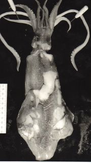
William and Elizabeth Stone at Ingatestone c.1865. Posted by Picasa


Enlargement. White gravel "hoggin" path at Mill Green, below the foot of William Stone late 1860's. Posted by Picasa


June 16 2006. I visited Mill Green by the route of my late Great Uncle William Stone, who lived there while working for the Eastern Counties and later the Great Eastern Railway at their London Terminus, commuting each day and presumably starting with a walk down the hill to Ingatestone Station built in 1846 about 15 years earlier. I was not able to match the doorway of his parents cottage, termed 40 Mill Green in the 1851 census, to the surviving and exposed fronts of buildings facing Mill Green Road and Hardings Lane.
The Flemish bonding of the red bricks made locally by Thomas and Frederick Bangs of the Mill Green Old Kiln is seen on the photograph and local buildings of various 18th and 19th Century ages. The newly named Mill Green cottage on the N.E. corner of Mill Green Road and Hardings Lane had a front path made out of similar bricks and also a wall in which the bricks show dimensions of 220 mm by 110 mm by 65 mm, with a repeat vertical distance inclusive of mortar averaging 81 mm. On the photograph, William Stone
Senior (bapt. October 27, 1816 – April 25, 1870) looks to be 24 courses of these bricks tall, and his wife 22 (Elizabeth Wilkinson (1818-1874) at Margasetting) courses, although the perspective is probably misleading with his height then coming out at six foot four and hers five foot ten!

The usual guideline for laying the usual bricks of Victorian London (thickness 64 to 70 mm) was not more than one foot (305 mm) for four courses, which is less than 76 mm for the repeat distance and simply less than 24/4 feet = six feet for William Stone. At the adjacent Fryerning Church there is a north chapel extension of bricks of about the right age, with dimensions of 215 x 100 x 60 mm exposed on the corner, repeating at 76 mm.

Ingatestone Train station was built in 1846 and shows two types of red bricks, which may of course have been brought in by train. One type is more pink and weathered, with the grog of 21 mm diameter (sand pellets added by the brickmaker) raised and often somewhat grey or white in colour. Examples of this type, measured while waiting for the train (a convenient if unusual pastime) had dimensions of 226 x 116 x 62 mm, repeating at 76 mm and 210 x 115 x 60 mm repeating at 75 mm. The associated old, unreplaced, but less weathered bricks with a darker red colour and finer or absent grog included 195 x 102 x 62 mm, repeating at 73 mm, and 230 x 105 x 61 mm repeating at 71 mm. Even the latter repeat distance would make William Stone, hay dealer of Mill Green, five feet seven inches tall and his wife, five feet one and a half inches. This seems more likely bearing in mind that the top of the door is higher than his head by three more courses. However it is known that their daughter Phoebe Stone used to combine the role of barmaid and bouncer in my great Grandmother’s public house in Stepney in the 1870’s. She also looks to be quite a large lady in wedding photographs.

This visit to Mill Green was also concerned with the gravels, which were seen in the various places and the Norman parts of Fryerning and Ingatestone Churches. It is easier to write immediately about the bricks and walls. It should be noted that the "puddingstone" of these church wall architectural descriptions is iron oxide cemented gravel (ferricrete) and not the silica cemented, Eocene, true Hertfordshire Puddingstone also sometimes seen in Essex churches.
June 18 2006. a) The Ingatestone. The oldest geological and historical object on display at Ingatestone Church is the yellowish silica cemented sandstone or quartzite, glacial erratic, which has a size and position on the churchyard suitable for assisting people to remount horses there. When A. E. Salter guided the Geologist’s Association to Ingatestone in 1906 (see their proceedings) he claimed that this was a Roman milestone, The Ingatestone, which gave its name to the village. At least two objections can be made despite the existence of the straight Roman Road, now old A12, just west of the churchyard. Romans used cylindrical dressed stone pillars, with inscriptions about emperors and distances cut into them in a suitably civilised manner, not erratics potentially available from Boulder Clay 400 m to the north. Secondly in the Domesday book the manor held by the Saxon nuns of Barking Abbey, which probably contained the church dedicated to St. Edmund and St. Mary, and three adjacent manors which were held by secular Saxons before 1066, were just termed Inga. These other manors probably included Fryerning, where the church is also dedicated to St. Mary, like the Abbey of the Nuns at Barking. St. Edmund was killed in 869 and legends have his body being transported to and from London from Bury St. Edmunds in 1016, presumably along the A12, and rested at the nuns new church at Inga. On the other hand, there is evidence that in 1777 the cross roads forming the nucleus of the village, about 50 yards north of the stone contained the English 23 miles from London stone, which would correspond to the position of the Roman 25 miles from London Stone (their miles being 142 yards less than an English one of 1760, and the baseline or route from London perhaps slightly different). So perhaps this glacial erratic became a less formal marker?


B) London Clay concretions and Barking Abbey. The next historically oldest stories at Ingatestone Church are present in the north wall of the nave, of early Norman age like most of Fryerning Church according to architectural books. Actually these walls look more like the fabric of the late Saxon Paglesham Church and could have been built for the Nuns before Norman windows etc. were put in. Fryerning Church is also dedicated to St. Mary and shows abundant ferricrete Pleistocene gravel blocks, plus Roman bricks and the large isolated flints and other cobbles locally available from the earlier Pleistocene Old Mead deposits. These features are reproduced in Ingatestone Church where I managed to find some additional calcareous claystone fragments, lacking veins, but otherwise resembling the London Clay septaria of eastern Essex church walls. It is difficult to prove that source with glacial deposits so close, but there is no evidence that they are not from the London Clay and had a typical matrix colouration of greyish orange in the Mansell classification, with numerical colours recorded on separate adjacent stones of up to 120 mm length as 10YR 7/4, 10YR7/2, 10YR 7/6 and 10R 6/2. What is significant is that I could not see them in the much larger area of the same fabric of Fryerning; despite looking for them and being familiar with them in the east. True septarian claystones, of a different appearance, probably crop out in the uppermost Claygate Member at Fryerning and would be more common in adjacent lower ground near Ingatestone. However, it s more likely that these stones were probably imported with the ferricrete along the River Wid and Roman Road from Chelmsford.

Wednesday, June 21, 2006

June 5 2006. My relatives lived at Mill Green, Essex. The southern edge of Mill Green Common (Essex) is of geological interest in being where Monckton & Herries (Proceedings of the Geologist’s Association volume 11, p.22) discovered casts of univalves (i.e. gastropod shells) in a seven foot section of the Bagshot Formation dug by 1888 below a thinner layer of the extracted gravels. Normally the lower Bagshot Formation is devoid of fossils and this discovery confirmed that it was a marine, nearshore deposit, of similar age to the youngest parts of the London Clay exposed in Essex and Kent. Earlier geological accounts of Mill Green missed these fossils, probably because the pits were not so deep. Since then the relevant area has been made into gardens and woodland. Water for brick making and cottages was provided by a springline at the base of the overlying white micaceous Eocene sands of the Bagshot Formation. The latter crops out on the south side of Mill Green Common east of the cottages built before 1777. The main part of the common to the north of there and to the south of the kiln was occupied by early Pleistocene gravels and reworked Bagshot sands or clays termed the old Head by the geological survey. This yielded a third mineral aiding the cottage development, a form of hard core or road aggregate termed hoggin, composed of white coarse gravel grade flints and a few coarser cobbles (> 64 mm in geological definition) of more angular flint, quartz, quartzite and other stones introduced by an early glaciation of Essex.

Monday, June 12, 2006

May 16 2006. Returning to the topic of the history of geology raised by the visit to the Prestwich 1853 section at Southend, there are books out on his English contemporary “Charles Darwin, Geologist” (by Sandra Herbert, 2005 in Cornell University Press, Ithaca N.Y.) and “The map that changed the World” made by William Smith in 1801 (by Simon Winchester 2001 Viking Press, 2002 Penguin Books). Sandra Herbert suggests that Darwin was a true geologist but has tended not to be regarded as such because he did not do English stratigraphical work like Prestwich and of course is better known as a biologist and geological thinker. Prestwich is much closer to the concept of a Victorian field geologist inspired by the work of William Smith and making major corrections to his stratigraphy and mapping of south-east England. Smith appears to have had the new idea of correlating rocks by their animal fossil content, particularly ammonites, in the Bath to Yorkshire tract of south-east tilted layers, which he regarded as being deposited on this slope and overlain by loose gravels which he interpreted as Diluvium formed by the Biblical Flood. During the period 1800 to 1807 Smith worked partly on the Norfolk coast and produced a lost work, evidently seen by the first proper geological author on that area Samuel Woodward (see Yorkshire Geological Society Proceedings v.15 p.23 by Dr. L.R. COX). He also set up house in London during this later period and must have encounted the common knowledge that the London Clay rested upon sands and then the chalk in artesian wells then starting to be sunk there. He therefore presumed that the fifty-foot cliffs of stratified glacial deposits of clay at Happisburgh in Norfolk were also London Clay and not the generally thinner and unstratified Diluvium. Glaciation as an origin of these deposits was not fully accepted until after 1840 and taxonomy of ammonites was not exact or confident enough to determine that his subsequently illustrated London Clay ammonite from Happisburgh was the same as those in the Jurassic clay concretions of Yorkshire and had actually been reworked into the later deposit. Meanwhile in the London area, his ideas were taken up by James Sowerby and other gentleman who promptly found additional ammonites from the Yorkshire Jurassic in the London Clay sites of Highgate Hill and Minster Cliffs (opposite Southend) which they more correctly correlated using the nautiloids from the London Clay itself. It is still unclear, at least to me, where these ammonites came from in these southeast England sites lying beyond the subsequently mapped area of Boulder Clay till deposited by the most extensive ice sheets. The Sowerby specimen of Decipia decipiens (originally from the Jurassic Corallian strata) is described as drift Highgate Hill, and his middle has Amaltheus margaritatus (figured as London clay Ammonites acutus) as drift at Minster in the catalogue of Natural History Museum ammonites by D. Phillips (published 1977). Neither locality shows very much in the way of post-Eocene gravels to confuse early investigators with extensive London Clay to look at there. I wonder whether the Minster specimen was not actually ballast in a ship from Yorkshire, which had called at the port of Sheemess near Minster and then sold to tourists. The Highgate specimen could also have been mixed-up by dealers in fossils, or introduced as building stone etc. Certainly there are specimens labelled Highgate in museums, which came from elsewhere. Reading Museum has a very large Yorkshire Jurassic nautiloid concretion dug up recently in the road near Windsor Castle, and on the mapped London Clay, rather than Boulder Clay or gravels. On the other hand, it is evident from even larger stones incorporated into old churches (probably from pagan sites) and smaller ones commonly seen in fields that some Yorkshire or other northern rocks do occur south-east of the officially mapped area of glacial till in Essex. But as noted last week it is far more common to find loose stones that have been moved north by rivers during the ice age from the Cretaceous rocks of Dent where neither of the Sowerby Jurassic ammonites occur insitu. What interested me last week was that even a later skilled investigator like Prestwich had made rather vague notes compared to what I could do in a few minutes on a less clean cliff, with a modern builders tape measure.

Saturday, June 10, 2006


Loligo forbesi adult from fish shop. Posted by Picasa

Dorsal view of head and tentacles. Posted by Picasa

Dorsal View. Loligo forbesi adult from fish shop reduced by 70% relative to specimen (black) from beach (over two days decay). Posted by Picasa

Ventral View. Loligo forbesi adult from fish shop reduced by 70% relative to specimen (black) from beach (over two days decay). Posted by Picasa

Wednesday, June 07, 2006

May 12 2006. Being in doubt about the field identification and to clean the beach with the gulls evidently on strike (or more likely on distant nest sites), I removed the larger of the two squids and determine that it has enrolled triangular fins of Loligo forbesi Steenstrup extending 12 to 60 mm from the posterior apex within a revised estimate of the dorsal mantle = gladius length of 134 mm and unchanged head and arm length of 80 mm. Judging from the paced distance from the breakwater it had moved one metre to the east in three subsequent tides after stranding exactly 2-0 days before being collected. However, it and the adjacent crab, weed etc., suggest that the three later tides had not moved it so far and merely rotated the head round parallel to the mantle as it became more loose. It was determined that one of the two tentacles was actually present as a thin white thread extending to the tip of the much or conspicuous eight arms and had lost the club of sackers. The other one was not positively identified even when the arms were manipulated and it is easy to see that fossil squid with eight arms might have once had two additional different appendages when alive. There had been no rain and much sunshine since it stranded and shrinkage by dehydration had cracked the curved gladius into three parts and reduced the width of the mantle beyond the fins from 30 to 26 mm. The predicted level of the tides were 0.1 m lower for the first one and 0.1 m higher for the other two, but it is possible that they did not do much more than wet the squid which sank like a stone when tested in sea-water. The jellyfish and other squid were not rediscovered but could have been overlooked during a short visit. The other squid probably was alsoLoligo forbesi.

The morphology of this and other cephalopods has been interpreted by analogy with the neutral buoyancy of submarines and the lift plus jet propulsion by analogy with jet fighters. The Elephant in the room in this good work by a now aging generation of English marine biologists in that in statics there is a trade-off between a lack of exact neutral buoyancy and the convenient horizontal posture of these predators, when they are denser than sea-water.

The illustrations show the adult shape of Loligo forbesi from a fish shop and not distorted like those in preservatives reduced by 70% for comparison with the more juvenile specimen shrunk by decay before stranding on May 10 and by drying on the beach fore two days. The lower surface in life (termed ventral) shows the funnel used for jet propulsion with water ejected from the mantle cavity and the upper (dorsal) surface is darker with the skin damaged in the fish shop and not on the beach (the dark colour of the beach specimen is due to the method of making the image but the skin is intact, with spots on the dorsal side and arms, and not on the tentacles or ventral side. The only sign of the two tentacles on the image of the beach specimen are thinner lines at the tip of the arms and in one place near their base, while in the fish shop they are thicker, longer and terminate in clubs bearing suckers. Both specimens showed enrolled triangular fins, which are unrolled in the fish shop specimen with dissection pins.